You are here: Home > Network List > TA - USArray Transportable Network (new EarthScope stations) Stations List
> Station C34A RKJ Ranch, Bemidji, MN, USA > Earthquake Result Viewer
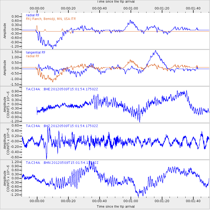
C34A RKJ Ranch, Bemidji, MN, USA - Earthquake Result Viewer
*The percent match for this event was below the threshold and hence no stack was calculated.
| Earthquake location: |
North Of Ascension Island |
| Earthquake latitude/longitude: |
-1.0/-13.6 |
| Earthquake time(UTC): |
2012/05/09 (130) 14:49:51 GMT |
| Earthquake Depth: |
12 km |
| Earthquake Magnitude: |
5.5 MW, 5.0 MS, 5.4 MB, 5.6 MW |
| Earthquake Catalog/Contributor: |
WHDF/NEIC |
|
| Network: |
TA USArray Transportable Network (new EarthScope stations) |
| Station: |
C34A RKJ Ranch, Bemidji, MN, USA |
| Lat/Lon: |
47.65 N/94.91 W |
| Elevation: |
441 m |
|
| Distance: |
84.8 deg |
| Az: |
317.85 deg |
| Baz: |
97.072 deg |
| Ray Param: |
$rayparam |
*The percent match for this event was below the threshold and hence was not used in the summary stack. |
|
| Radial Match: |
11.151401 % |
| Radial Bump: |
400 |
| Transverse Match: |
12.001095 % |
| Transverse Bump: |
400 |
| SOD ConfigId: |
446234 |
| Insert Time: |
2012-08-05 05:19:23.405 +0000 |
| GWidth: |
2.5 |
| Max Bumps: |
400 |
| Tol: |
0.001 |
|
Signal To Noise
| Channel | StoN | STA | LTA |
| TA:C34A: :BHZ:20120509T15:01:54.17502Z | 1.2660182 | 1.1602821E-7 | 9.164814E-8 |
| TA:C34A: :BHN:20120509T15:01:54.17502Z | 1.9177611 | 3.9915253E-7 | 2.0813465E-7 |
| TA:C34A: :BHE:20120509T15:01:54.17502Z | 1.6976113 | 2.6400738E-7 | 1.5551699E-7 |
| Arrivals |
| Ps | |
| PpPs | |
| PsPs/PpSs | |


