You are here: Home > Network List > TA - USArray Transportable Network (new EarthScope stations) Stations List
> Station N38A Joe's South Fork Station, Corydon, IA, USA > Earthquake Result Viewer
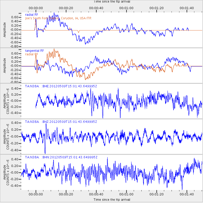
N38A Joe's South Fork Station, Corydon, IA, USA - Earthquake Result Viewer
*The percent match for this event was below the threshold and hence no stack was calculated.
| Earthquake location: |
North Of Ascension Island |
| Earthquake latitude/longitude: |
-1.0/-13.6 |
| Earthquake time(UTC): |
2012/05/09 (130) 14:49:51 GMT |
| Earthquake Depth: |
12 km |
| Earthquake Magnitude: |
5.5 MW, 5.0 MS, 5.4 MB, 5.6 MW |
| Earthquake Catalog/Contributor: |
WHDF/NEIC |
|
| Network: |
TA USArray Transportable Network (new EarthScope stations) |
| Station: |
N38A Joe's South Fork Station, Corydon, IA, USA |
| Lat/Lon: |
40.79 N/93.24 W |
| Elevation: |
317 m |
|
| Distance: |
82.8 deg |
| Az: |
311.165 deg |
| Baz: |
97.517 deg |
| Ray Param: |
$rayparam |
*The percent match for this event was below the threshold and hence was not used in the summary stack. |
|
| Radial Match: |
57.586044 % |
| Radial Bump: |
400 |
| Transverse Match: |
39.591084 % |
| Transverse Bump: |
400 |
| SOD ConfigId: |
446234 |
| Insert Time: |
2012-08-05 05:19:37.294 +0000 |
| GWidth: |
2.5 |
| Max Bumps: |
400 |
| Tol: |
0.001 |
|
Signal To Noise
| Channel | StoN | STA | LTA |
| TA:N38A: :BHZ:20120509T15:01:43.649995Z | 1.791666 | 1.0991759E-7 | 6.1349375E-8 |
| TA:N38A: :BHN:20120509T15:01:43.649995Z | 0.6635181 | 8.599926E-8 | 1.2961102E-7 |
| TA:N38A: :BHE:20120509T15:01:43.649995Z | 1.5341425 | 1.5234559E-7 | 9.930342E-8 |
| Arrivals |
| Ps | |
| PpPs | |
| PsPs/PpSs | |


