You are here: Home > Network List > TA - USArray Transportable Network (new EarthScope stations) Stations List
> Station C06D Leavenworth, WQ, USA > Earthquake Result Viewer
C06D Leavenworth, WQ, USA - Earthquake Result Viewer
| Earthquake location: |
Guerrero, Mexico |
| Earthquake latitude/longitude: |
17.3/-100.8 |
| Earthquake time(UTC): |
2014/05/10 (130) 07:36:03 GMT |
| Earthquake Depth: |
35 km |
| Earthquake Magnitude: |
6.0 MB |
| Earthquake Catalog/Contributor: |
NEIC PDE/NEIC COMCAT |
|
| Network: |
TA USArray Transportable Network (new EarthScope stations) |
| Station: |
C06D Leavenworth, WQ, USA |
| Lat/Lon: |
47.92 N/120.89 W |
| Elevation: |
544 m |
|
| Distance: |
34.7 deg |
| Az: |
336.027 deg |
| Baz: |
144.746 deg |
| Ray Param: |
0.07751581 |
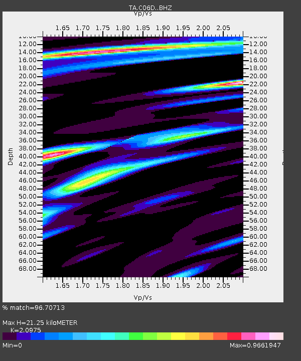
| Estimated Moho Depth: |
21.25 km |
| Estimated Crust Vp/Vs: |
2.10 |
| Assumed Crust Vp: |
6.597 km/s |
| Estimated Crust Vs: |
3.145 km/s |
| Estimated Crust Poisson's Ratio: |
0.35 |
|
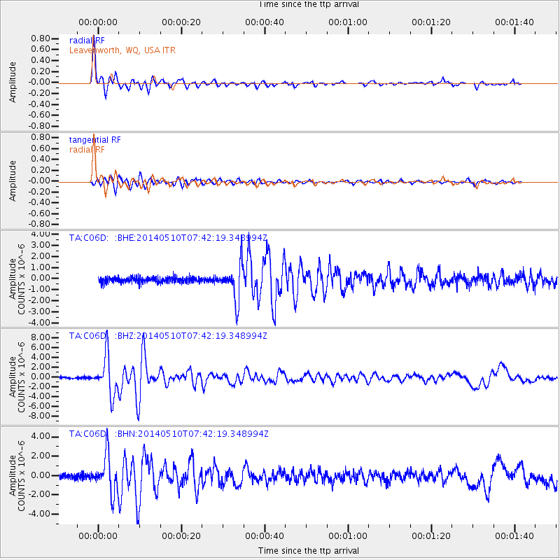
| Radial Match: |
96.70713 % |
| Radial Bump: |
281 |
| Transverse Match: |
91.542274 % |
| Transverse Bump: |
400 |
| SOD ConfigId: |
3390531 |
| Insert Time: |
2019-04-11 19:23:55.066 +0000 |
| GWidth: |
2.5 |
| Max Bumps: |
400 |
| Tol: |
0.001 |
|
Signal To Noise
| Channel | StoN | STA | LTA |
| TA:C06D: :BHZ:20140510T07:42:19.348994Z | 23.509895 | 4.1352864E-6 | 1.7589558E-7 |
| TA:C06D: :BHN:20140510T07:42:19.348994Z | 9.156285 | 2.0447847E-6 | 2.2332031E-7 |
| TA:C06D: :BHE:20140510T07:42:19.348994Z | 7.325449 | 1.739868E-6 | 2.375101E-7 |
| Arrivals |
| Ps | 3.8 SECOND |
| PpPs | 9.3 SECOND |
| PsPs/PpSs | 13 SECOND |


