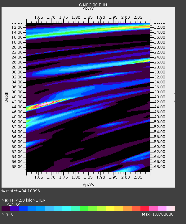
MPG Montagne des Peres, French Guyana - Earthquake Result Viewer
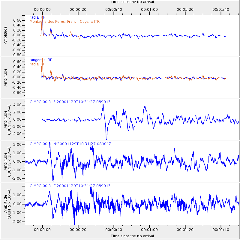
Earthquake location: Near Coast Of Northern Chile
Earthquake latitude/longitude: -24.9/-70.9
Earthquake time(UTC): 2000/11/29 (334) 10:25:13 GMT
Earthquake Depth: 58 km
Earthquake Magnitude: 5.8 MB, 5.9 MS, 6.4 MW, 6.3 MW
Earthquake Catalog/Contributor: WHDF/NEIC
Network: G GEOSCOPE
Station: MPG Montagne des Peres, French Guyana
Lat/Lon: 5.11 N/52.64 W
Elevation: 147 m
Distance: 34.7 deg
Az: 33.226 deg
Baz: 209.979 deg
Ray Param: 0.077462554
Estimated Moho Depth: 42.0 km
Estimated Crust Vp/Vs: 1.69
Assumed Crust Vp: 6.472 km/s
Estimated Crust Vs: 3.83 km/s
Estimated Crust Poisson's Ratio: 0.23
Radial Match: 94.10096 %
Radial Bump: 334
Transverse Match: 72.679985 %
Transverse Bump: 400
SOD ConfigId: 20082
Insert Time: 2010-02-26 23:33:19.503 +0000
GWidth: 2.5
Max Bumps: 400
Tol: 0.001

Signal To Noise

ChannelStoNSTALTA
G:MPG:00:BHN:20001129T10:31:27.08901Z5.5769638.1212767E-71.4562184E-7
G:MPG:00:BHE:20001129T10:31:27.08901Z2.84762025.6400455E-71.9806173E-7
G:MPG:00:BHZ:20001129T10:31:27.08901Z7.51998571.5800425E-62.1011243E-7
Arrivals
Ps4.9 SECOND
PpPs16 SECOND
PsPs/PpSs21 SECOND