You are here: Home > Network List > X812 - Deep Structure of Three Continental Sutures in Eastern North America Stations List
> Station QM30 Fish River Lake, Maine, USA > Earthquake Result Viewer
QM30 Fish River Lake, Maine, USA - Earthquake Result Viewer
| Earthquake location: |
Guerrero, Mexico |
| Earthquake latitude/longitude: |
17.3/-100.8 |
| Earthquake time(UTC): |
2014/05/10 (130) 07:36:03 GMT |
| Earthquake Depth: |
35 km |
| Earthquake Magnitude: |
6.0 MB |
| Earthquake Catalog/Contributor: |
NEIC PDE/NEIC COMCAT |
|
| Network: |
X8 Deep Structure of Three Continental Sutures in Eastern North America |
| Station: |
QM30 Fish River Lake, Maine, USA |
| Lat/Lon: |
46.83 N/68.76 W |
| Elevation: |
262 m |
|
| Distance: |
39.6 deg |
| Az: |
34.821 deg |
| Baz: |
232.625 deg |
| Ray Param: |
0.07483901 |
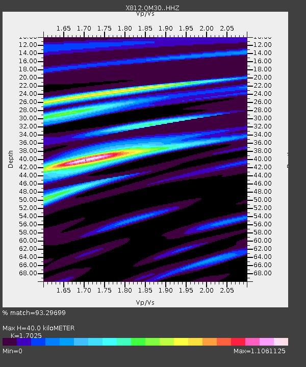
| Estimated Moho Depth: |
40.0 km |
| Estimated Crust Vp/Vs: |
1.70 |
| Assumed Crust Vp: |
6.419 km/s |
| Estimated Crust Vs: |
3.77 km/s |
| Estimated Crust Poisson's Ratio: |
0.24 |
|
| Radial Match: |
93.29699 % |
| Radial Bump: |
283 |
| Transverse Match: |
80.178566 % |
| Transverse Bump: |
400 |
| SOD ConfigId: |
3390531 |
| Insert Time: |
2019-04-11 19:24:40.695 +0000 |
| GWidth: |
2.5 |
| Max Bumps: |
400 |
| Tol: |
0.001 |
|

Signal To Noise
| Channel | StoN | STA | LTA |
| X8:QM30: :HHZ:20140510T07:43:01.36999Z | 27.927532 | 2.6944688E-6 | 9.648073E-8 |
| X8:QM30: :HHN:20140510T07:43:01.36999Z | 15.626061 | 1.0385708E-6 | 6.646402E-8 |
| X8:QM30: :HHE:20140510T07:43:01.36999Z | 16.424974 | 1.2649488E-6 | 7.7013745E-8 |
| Arrivals |
| Ps | 4.7 SECOND |
| PpPs | 16 SECOND |
| PsPs/PpSs | 20 SECOND |


