You are here: Home > Network List > G - GEOSCOPE Stations List
> Station MPG Montagne des Peres, French Guyana > Earthquake Result Viewer
MPG Montagne des Peres, French Guyana - Earthquake Result Viewer
| Earthquake location: |
South Sandwich Islands Region |
| Earthquake latitude/longitude: |
-55.6/-29.9 |
| Earthquake time(UTC): |
2000/11/07 (312) 00:18:04 GMT |
| Earthquake Depth: |
10 km |
| Earthquake Magnitude: |
6.7 MS, 6.8 MW, 6.6 MW |
| Earthquake Catalog/Contributor: |
WHDF/NEIC |
|
| Network: |
G GEOSCOPE |
| Station: |
MPG Montagne des Peres, French Guyana |
| Lat/Lon: |
5.11 N/52.64 W |
| Elevation: |
147 m |
|
| Distance: |
63.4 deg |
| Az: |
334.457 deg |
| Baz: |
165.788 deg |
| Ray Param: |
0.05961358 |
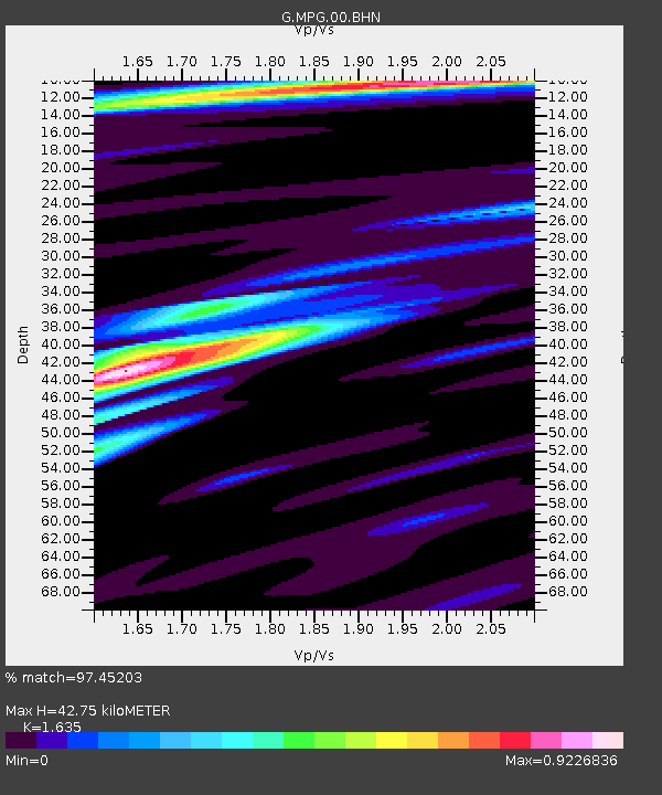
| Estimated Moho Depth: |
42.75 km |
| Estimated Crust Vp/Vs: |
1.63 |
| Assumed Crust Vp: |
6.472 km/s |
| Estimated Crust Vs: |
3.958 km/s |
| Estimated Crust Poisson's Ratio: |
0.20 |
|
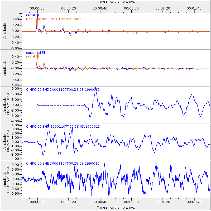
| Radial Match: |
97.45203 % |
| Radial Bump: |
368 |
| Transverse Match: |
78.569786 % |
| Transverse Bump: |
400 |
| SOD ConfigId: |
3744 |
| Insert Time: |
2010-02-26 23:33:22.077 +0000 |
| GWidth: |
2.5 |
| Max Bumps: |
400 |
| Tol: |
0.001 |
|
Signal To Noise
| Channel | StoN | STA | LTA |
| G:MPG:00:BHN:20001107T00:28:03.199001Z | 15.078332 | 1.5503489E-6 | 1.0281965E-7 |
| G:MPG:00:BHE:20001107T00:28:03.199001Z | 2.5289924 | 2.3101629E-7 | 9.134716E-8 |
| G:MPG:00:BHZ:20001107T00:28:03.199001Z | 21.131405 | 3.2395874E-6 | 1.5330676E-7 |
| Arrivals |
| Ps | 4.4 SECOND |
| PpPs | 17 SECOND |
| PsPs/PpSs | 21 SECOND |


