You are here: Home > Network List > G - GEOSCOPE Stations List
> Station MPG Montagne des Peres, French Guyana > Earthquake Result Viewer
MPG Montagne des Peres, French Guyana - Earthquake Result Viewer
| Earthquake location: |
Lake Tanganyika Region |
| Earthquake latitude/longitude: |
-8.0/30.7 |
| Earthquake time(UTC): |
2000/10/02 (276) 02:25:31 GMT |
| Earthquake Depth: |
34 km |
| Earthquake Magnitude: |
6.1 MB, 6.7 MS, 6.5 MW, 6.2 ME |
| Earthquake Catalog/Contributor: |
WHDF/NEIC |
|
| Network: |
G GEOSCOPE |
| Station: |
MPG Montagne des Peres, French Guyana |
| Lat/Lon: |
5.11 N/52.64 W |
| Elevation: |
147 m |
|
| Distance: |
84.1 deg |
| Az: |
275.974 deg |
| Baz: |
98.525 deg |
| Ray Param: |
0.04564408 |
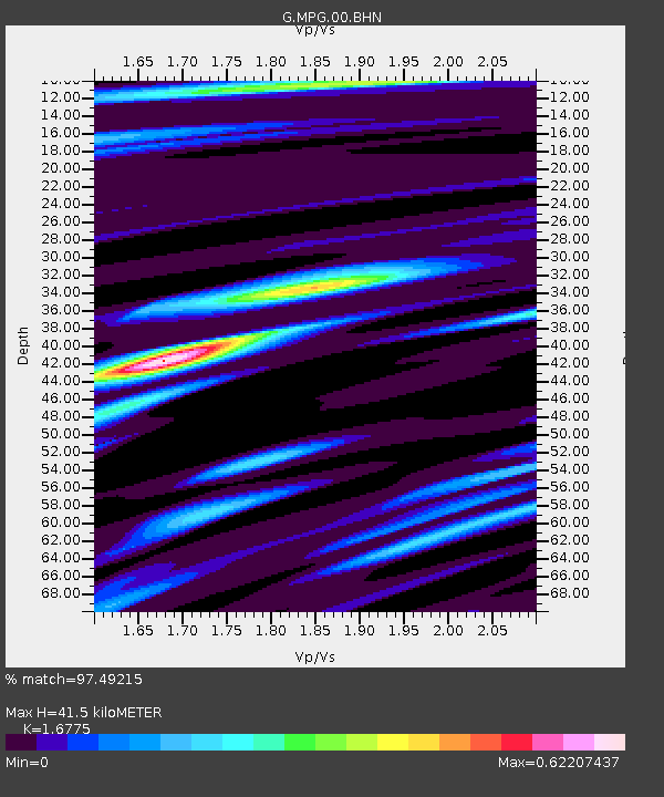
| Estimated Moho Depth: |
41.5 km |
| Estimated Crust Vp/Vs: |
1.68 |
| Assumed Crust Vp: |
6.472 km/s |
| Estimated Crust Vs: |
3.858 km/s |
| Estimated Crust Poisson's Ratio: |
0.22 |
|
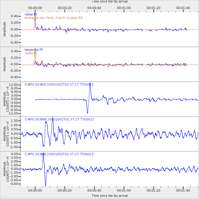
| Radial Match: |
97.49215 % |
| Radial Bump: |
280 |
| Transverse Match: |
91.39366 % |
| Transverse Bump: |
392 |
| SOD ConfigId: |
3744 |
| Insert Time: |
2010-02-26 23:33:23.514 +0000 |
| GWidth: |
2.5 |
| Max Bumps: |
400 |
| Tol: |
0.001 |
|
Signal To Noise
| Channel | StoN | STA | LTA |
| G:MPG:00:BHN:20001002T02:37:27.750002Z | 1.2751343 | 1.3443146E-7 | 1.05425336E-7 |
| G:MPG:00:BHE:20001002T02:37:27.750002Z | 1.7728826 | 2.0665678E-7 | 1.165654E-7 |
| G:MPG:00:BHZ:20001002T02:37:27.750002Z | 3.9364944 | 6.134364E-7 | 1.5583316E-7 |
| Arrivals |
| Ps | 4.5 SECOND |
| PpPs | 17 SECOND |
| PsPs/PpSs | 21 SECOND |


