You are here: Home > Network List > TA - USArray Transportable Network (new EarthScope stations) Stations List
> Station E36A McGregor, MN, USA > Earthquake Result Viewer
E36A McGregor, MN, USA - Earthquake Result Viewer
*The percent match for this event was below the threshold and hence no stack was calculated.
| Earthquake location: |
Easter Island Region |
| Earthquake latitude/longitude: |
-28.7/-112.6 |
| Earthquake time(UTC): |
2012/05/10 (131) 02:13:56 GMT |
| Earthquake Depth: |
10 km |
| Earthquake Magnitude: |
5.8 MS, 5.3 MB, 5.9 MW, 5.8 MW |
| Earthquake Catalog/Contributor: |
WHDF/NEIC |
|
| Network: |
TA USArray Transportable Network (new EarthScope stations) |
| Station: |
E36A McGregor, MN, USA |
| Lat/Lon: |
46.52 N/93.26 W |
| Elevation: |
393 m |
|
| Distance: |
76.9 deg |
| Az: |
13.573 deg |
| Baz: |
197.366 deg |
| Ray Param: |
$rayparam |
*The percent match for this event was below the threshold and hence was not used in the summary stack. |
|
| Radial Match: |
70.088326 % |
| Radial Bump: |
400 |
| Transverse Match: |
68.21784 % |
| Transverse Bump: |
400 |
| SOD ConfigId: |
446234 |
| Insert Time: |
2012-08-05 05:35:04.802 +0000 |
| GWidth: |
2.5 |
| Max Bumps: |
400 |
| Tol: |
0.001 |
|
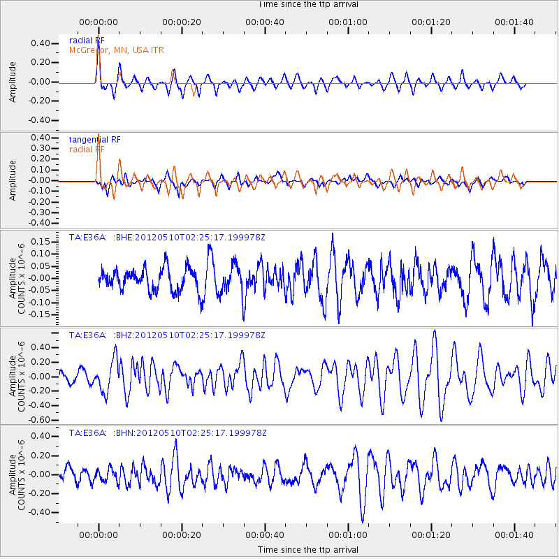
Signal To Noise
| Channel | StoN | STA | LTA |
| TA:E36A: :BHZ:20120510T02:25:17.199978Z | 3.440535 | 2.2384897E-7 | 6.506225E-8 |
| TA:E36A: :BHN:20120510T02:25:17.199978Z | 0.73377275 | 6.366661E-8 | 8.6766114E-8 |
| TA:E36A: :BHE:20120510T02:25:17.199978Z | 1.3401169 | 5.9148398E-8 | 4.4136748E-8 |
| Arrivals |
| Ps | |
| PpPs | |
| PsPs/PpSs | |


