You are here: Home > Network List > TA - USArray Transportable Network (new EarthScope stations) Stations List
> Station R38A Fenwick Farm, Montrose, MO, USA > Earthquake Result Viewer
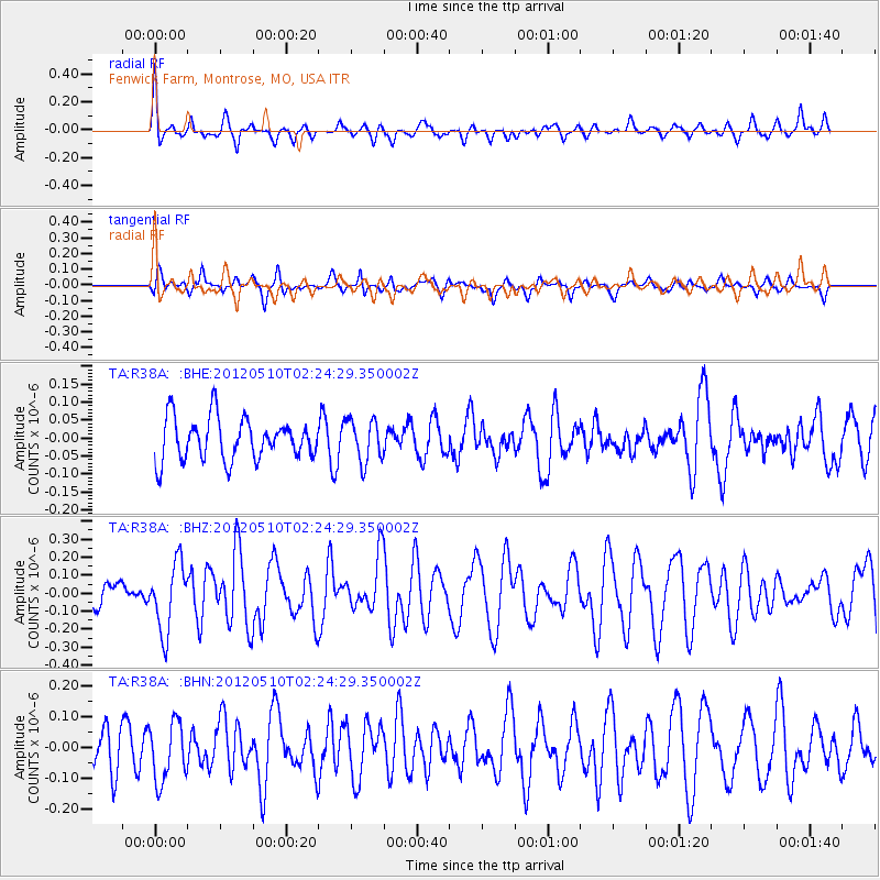
R38A Fenwick Farm, Montrose, MO, USA - Earthquake Result Viewer
*The percent match for this event was below the threshold and hence no stack was calculated.
| Earthquake location: |
Easter Island Region |
| Earthquake latitude/longitude: |
-28.7/-112.6 |
| Earthquake time(UTC): |
2012/05/10 (131) 02:13:56 GMT |
| Earthquake Depth: |
10 km |
| Earthquake Magnitude: |
5.8 MS, 5.3 MB, 5.9 MW, 5.8 MW |
| Earthquake Catalog/Contributor: |
WHDF/NEIC |
|
| Network: |
TA USArray Transportable Network (new EarthScope stations) |
| Station: |
R38A Fenwick Farm, Montrose, MO, USA |
| Lat/Lon: |
38.19 N/93.91 W |
| Elevation: |
237 m |
|
| Distance: |
68.8 deg |
| Az: |
15.705 deg |
| Baz: |
197.558 deg |
| Ray Param: |
$rayparam |
*The percent match for this event was below the threshold and hence was not used in the summary stack. |
|
| Radial Match: |
74.52882 % |
| Radial Bump: |
400 |
| Transverse Match: |
61.327305 % |
| Transverse Bump: |
400 |
| SOD ConfigId: |
446234 |
| Insert Time: |
2012-08-05 05:35:45.308 +0000 |
| GWidth: |
2.5 |
| Max Bumps: |
400 |
| Tol: |
0.001 |
|
Signal To Noise
| Channel | StoN | STA | LTA |
| TA:R38A: :BHZ:20120510T02:24:29.350002Z | 3.0839014 | 1.8919076E-7 | 6.134786E-8 |
| TA:R38A: :BHN:20120510T02:24:29.350002Z | 1.451001 | 9.509059E-8 | 6.553447E-8 |
| TA:R38A: :BHE:20120510T02:24:29.350002Z | 1.0005852 | 5.8032718E-8 | 5.799878E-8 |
| Arrivals |
| Ps | |
| PpPs | |
| PsPs/PpSs | |


