You are here: Home > Network List > TA - USArray Transportable Network (new EarthScope stations) Stations List
> Station U42A Revenden, AR, USA > Earthquake Result Viewer
U42A Revenden, AR, USA - Earthquake Result Viewer
| Earthquake location: |
Easter Island Region |
| Earthquake latitude/longitude: |
-28.7/-112.6 |
| Earthquake time(UTC): |
2012/05/10 (131) 02:13:56 GMT |
| Earthquake Depth: |
10 km |
| Earthquake Magnitude: |
5.8 MS, 5.3 MB, 5.9 MW, 5.8 MW |
| Earthquake Catalog/Contributor: |
WHDF/NEIC |
|
| Network: |
TA USArray Transportable Network (new EarthScope stations) |
| Station: |
U42A Revenden, AR, USA |
| Lat/Lon: |
36.35 N/91.24 W |
| Elevation: |
119 m |
|
| Distance: |
67.8 deg |
| Az: |
18.509 deg |
| Baz: |
200.204 deg |
| Ray Param: |
0.056732554 |
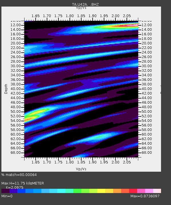
| Estimated Moho Depth: |
11.75 km |
| Estimated Crust Vp/Vs: |
2.10 |
| Assumed Crust Vp: |
6.53 km/s |
| Estimated Crust Vs: |
3.113 km/s |
| Estimated Crust Poisson's Ratio: |
0.35 |
|
| Radial Match: |
80.00064 % |
| Radial Bump: |
400 |
| Transverse Match: |
49.033188 % |
| Transverse Bump: |
400 |
| SOD ConfigId: |
446234 |
| Insert Time: |
2012-08-05 05:39:26.116 +0000 |
| GWidth: |
2.5 |
| Max Bumps: |
400 |
| Tol: |
0.001 |
|

Signal To Noise
| Channel | StoN | STA | LTA |
| TA:U42A: :BHZ:20120510T02:24:22.824978Z | 2.1765442 | 1.4652095E-7 | 6.7318155E-8 |
| TA:U42A: :BHN:20120510T02:24:22.824978Z | 2.4262366 | 1.18050785E-7 | 4.8655924E-8 |
| TA:U42A: :BHE:20120510T02:24:22.824978Z | 1.7224606 | 7.593059E-8 | 4.408263E-8 |
| Arrivals |
| Ps | 2.0 SECOND |
| PpPs | 5.4 SECOND |
| PsPs/PpSs | 7.4 SECOND |


