You are here: Home > Network List > G - GEOSCOPE Stations List
> Station MPG Montagne des Peres, French Guyana > Earthquake Result Viewer
MPG Montagne des Peres, French Guyana - Earthquake Result Viewer
| Earthquake location: |
El Salvador |
| Earthquake latitude/longitude: |
13.0/-88.7 |
| Earthquake time(UTC): |
2001/01/13 (013) 17:33:32 GMT |
| Earthquake Depth: |
60 km |
| Earthquake Magnitude: |
6.4 MB, 7.8 MS, 7.7 MW, 7.5 ME |
| Earthquake Catalog/Contributor: |
WHDF/NEIC |
|
| Network: |
G GEOSCOPE |
| Station: |
MPG Montagne des Peres, French Guyana |
| Lat/Lon: |
5.11 N/52.64 W |
| Elevation: |
147 m |
|
| Distance: |
36.4 deg |
| Az: |
99.168 deg |
| Baz: |
285.018 deg |
| Ray Param: |
0.076542005 |
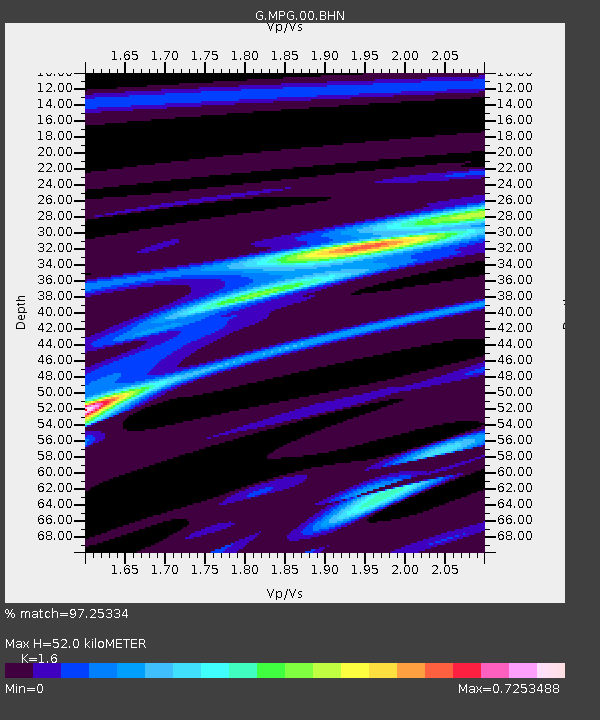
| Estimated Moho Depth: |
52.0 km |
| Estimated Crust Vp/Vs: |
1.60 |
| Assumed Crust Vp: |
6.472 km/s |
| Estimated Crust Vs: |
4.045 km/s |
| Estimated Crust Poisson's Ratio: |
0.18 |
|
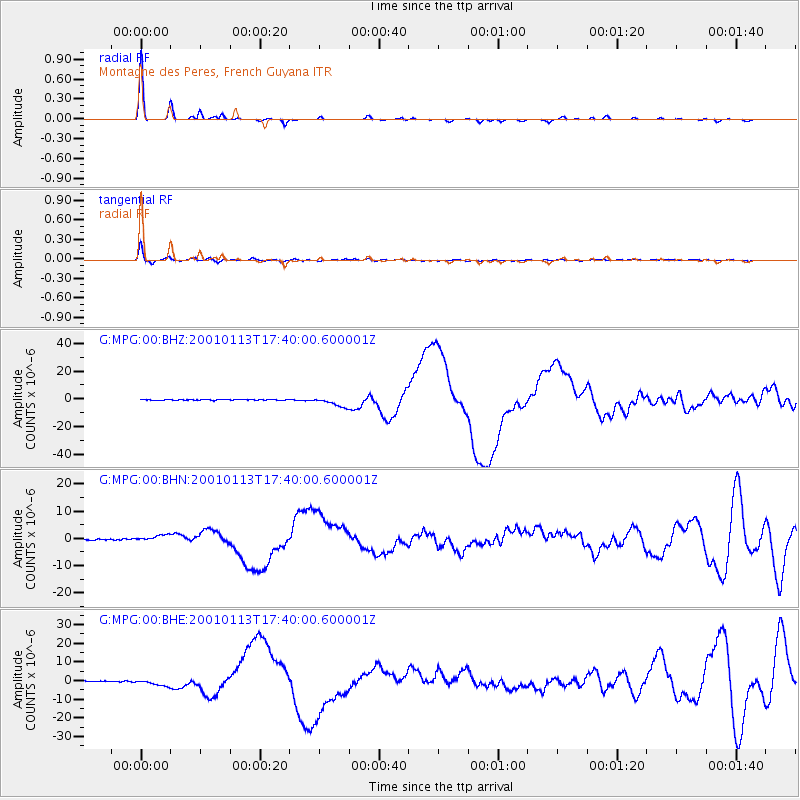
| Radial Match: |
97.25334 % |
| Radial Bump: |
165 |
| Transverse Match: |
90.23461 % |
| Transverse Bump: |
344 |
| SOD ConfigId: |
3744 |
| Insert Time: |
2010-02-26 23:33:39.227 +0000 |
| GWidth: |
2.5 |
| Max Bumps: |
400 |
| Tol: |
0.001 |
|
Signal To Noise
| Channel | StoN | STA | LTA |
| G:MPG:00:BHN:20010113T17:40:00.600001Z | 4.7881155 | 1.1736802E-6 | 2.451236E-7 |
| G:MPG:00:BHE:20010113T17:40:00.600001Z | 6.5636325 | 1.7547577E-6 | 2.673455E-7 |
| G:MPG:00:BHZ:20010113T17:40:00.600001Z | 12.80776 | 3.5230519E-6 | 2.7507167E-7 |
| Arrivals |
| Ps | 5.2 SECOND |
| PpPs | 19 SECOND |
| PsPs/PpSs | 24 SECOND |


