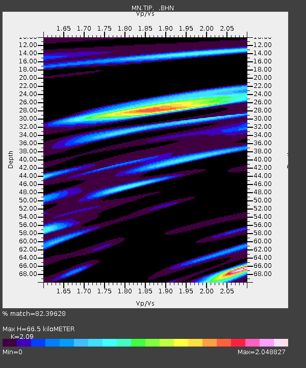
TIP Timpagrande, Italy - Earthquake Result Viewer

Earthquake location: Afghanistan-Tajikistan Bord Reg.
Earthquake latitude/longitude: 38.6/70.4
Earthquake time(UTC): 2012/05/12 (133) 23:28:43 GMT
Earthquake Depth: 10 km
Earthquake Magnitude: 6.0 MB, 5.7 MS, 5.7 MW, 5.9 MW
Earthquake Catalog/Contributor: WHDF/NEIC
Network: MN MEDNET Project
Station: TIP Timpagrande, Italy
Lat/Lon: 39.18 N/16.76 E
Elevation: 789 m
Distance: 41.2 deg
Az: 288.248 deg
Baz: 73.189 deg
Ray Param: 0.073941745
Estimated Moho Depth: 66.5 km
Estimated Crust Vp/Vs: 2.09
Assumed Crust Vp: 6.1 km/s
Estimated Crust Vs: 2.919 km/s
Estimated Crust Poisson's Ratio: 0.35
Radial Match: 82.39628 %
Radial Bump: 400
Transverse Match: 72.14123 %
Transverse Bump: 400
SOD ConfigId: 446234
Insert Time: 2012-08-05 05:57:33.194 +0000
GWidth: 2.5
Max Bumps: 400
Tol: 0.001

Signal To Noise

ChannelStoNSTALTA
MN:TIP: :BHZ:20120512T23:35:57.464012Z5.5758682.7066187E-74.8541658E-8
MN:TIP: :BHN:20120512T23:35:57.464012Z0.978899665.4950135E-85.6134596E-8
MN:TIP: :BHE:20120512T23:35:57.464012Z4.998022.0945936E-74.1908468E-8
Arrivals
Ps13 SECOND
PpPs32 SECOND
PsPs/PpSs44 SECOND