You are here: Home > Network List > TA - USArray Transportable Network (new EarthScope stations) Stations List
> Station G35A Watkins, MN, USA > Earthquake Result Viewer
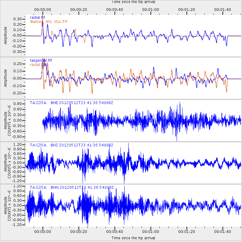
G35A Watkins, MN, USA - Earthquake Result Viewer
*The percent match for this event was below the threshold and hence no stack was calculated.
| Earthquake location: |
Afghanistan-Tajikistan Bord Reg. |
| Earthquake latitude/longitude: |
38.6/70.4 |
| Earthquake time(UTC): |
2012/05/12 (133) 23:28:43 GMT |
| Earthquake Depth: |
10 km |
| Earthquake Magnitude: |
6.0 MB, 5.7 MS, 5.7 MW, 5.9 MW |
| Earthquake Catalog/Contributor: |
WHDF/NEIC |
|
| Network: |
TA USArray Transportable Network (new EarthScope stations) |
| Station: |
G35A Watkins, MN, USA |
| Lat/Lon: |
45.22 N/94.49 W |
| Elevation: |
361 m |
|
| Distance: |
95.4 deg |
| Az: |
349.3 deg |
| Baz: |
11.877 deg |
| Ray Param: |
$rayparam |
*The percent match for this event was below the threshold and hence was not used in the summary stack. |
|
| Radial Match: |
49.320057 % |
| Radial Bump: |
391 |
| Transverse Match: |
43.979755 % |
| Transverse Bump: |
400 |
| SOD ConfigId: |
446234 |
| Insert Time: |
2012-08-05 06:02:17.020 +0000 |
| GWidth: |
2.5 |
| Max Bumps: |
400 |
| Tol: |
0.001 |
|
Signal To Noise
| Channel | StoN | STA | LTA |
| TA:G35A: :BHZ:20120512T23:41:36.54998Z | 1.1379943 | 3.1696217E-7 | 2.7852704E-7 |
| TA:G35A: :BHN:20120512T23:41:36.54998Z | 0.8506813 | 3.2675118E-7 | 3.8410525E-7 |
| TA:G35A: :BHE:20120512T23:41:36.54998Z | 1.1662189 | 2.90538E-7 | 2.491282E-7 |
| Arrivals |
| Ps | |
| PpPs | |
| PsPs/PpSs | |


