You are here: Home > Network List > TA - USArray Transportable Network (new EarthScope stations) Stations List
> Station H37A Dierke Farm, Cannon Falls, MN, USA > Earthquake Result Viewer
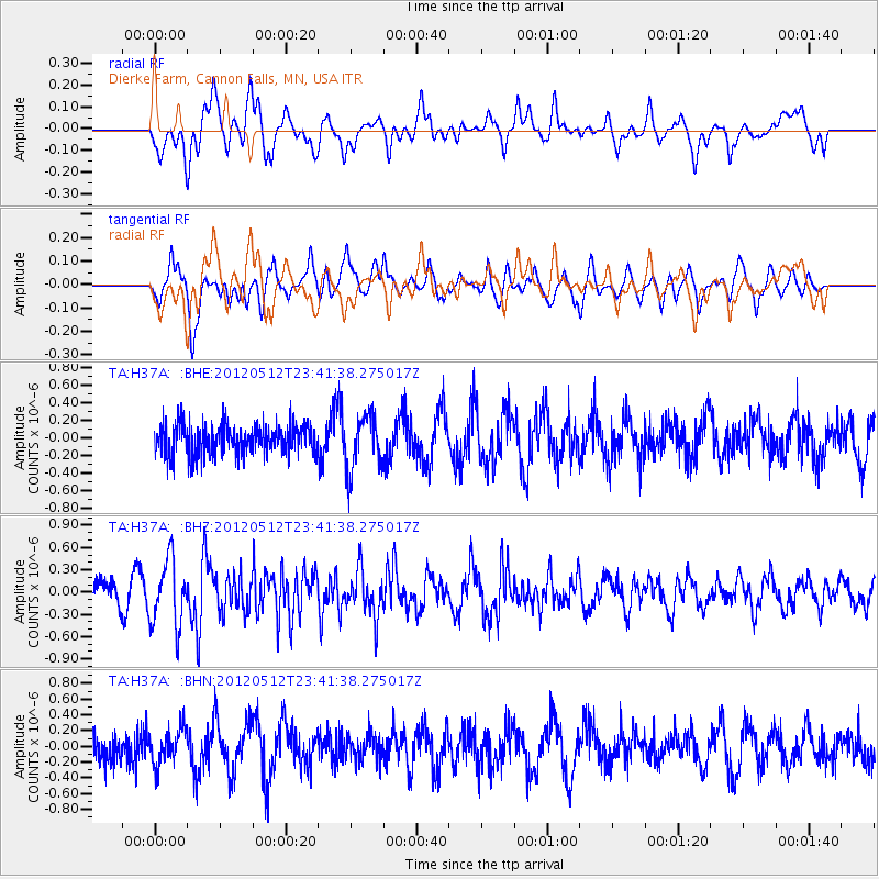
H37A Dierke Farm, Cannon Falls, MN, USA - Earthquake Result Viewer
*The percent match for this event was below the threshold and hence no stack was calculated.
| Earthquake location: |
Afghanistan-Tajikistan Bord Reg. |
| Earthquake latitude/longitude: |
38.6/70.4 |
| Earthquake time(UTC): |
2012/05/12 (133) 23:28:43 GMT |
| Earthquake Depth: |
10 km |
| Earthquake Magnitude: |
6.0 MB, 5.7 MS, 5.7 MW, 5.9 MW |
| Earthquake Catalog/Contributor: |
WHDF/NEIC |
|
| Network: |
TA USArray Transportable Network (new EarthScope stations) |
| Station: |
H37A Dierke Farm, Cannon Falls, MN, USA |
| Lat/Lon: |
44.58 N/92.92 W |
| Elevation: |
321 m |
|
| Distance: |
95.8 deg |
| Az: |
348.068 deg |
| Baz: |
13.101 deg |
| Ray Param: |
$rayparam |
*The percent match for this event was below the threshold and hence was not used in the summary stack. |
|
| Radial Match: |
58.432854 % |
| Radial Bump: |
400 |
| Transverse Match: |
69.153786 % |
| Transverse Bump: |
371 |
| SOD ConfigId: |
446234 |
| Insert Time: |
2012-08-05 06:02:34.151 +0000 |
| GWidth: |
2.5 |
| Max Bumps: |
400 |
| Tol: |
0.001 |
|
Signal To Noise
| Channel | StoN | STA | LTA |
| TA:H37A: :BHZ:20120512T23:41:38.275017Z | 2.7248762 | 4.4825723E-7 | 1.6450554E-7 |
| TA:H37A: :BHN:20120512T23:41:38.275017Z | 0.8925125 | 2.171852E-7 | 2.4334136E-7 |
| TA:H37A: :BHE:20120512T23:41:38.275017Z | 1.8368136 | 3.1384914E-7 | 1.7086609E-7 |
| Arrivals |
| Ps | |
| PpPs | |
| PsPs/PpSs | |


