You are here: Home > Network List > TA - USArray Transportable Network (new EarthScope stations) Stations List
> Station L39A Vinton, IA, USA > Earthquake Result Viewer
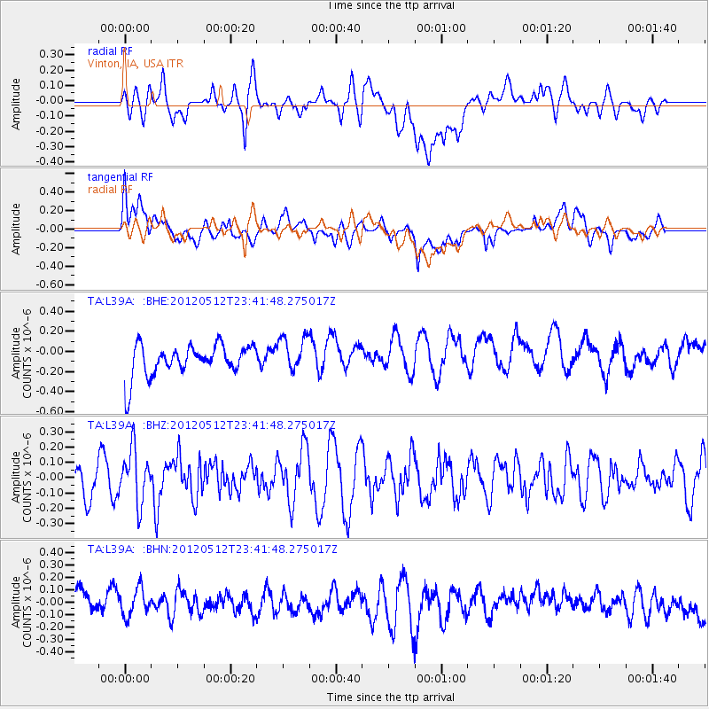
L39A Vinton, IA, USA - Earthquake Result Viewer
*The percent match for this event was below the threshold and hence no stack was calculated.
| Earthquake location: |
Afghanistan-Tajikistan Bord Reg. |
| Earthquake latitude/longitude: |
38.6/70.4 |
| Earthquake time(UTC): |
2012/05/12 (133) 23:28:43 GMT |
| Earthquake Depth: |
10 km |
| Earthquake Magnitude: |
6.0 MB, 5.7 MS, 5.7 MW, 5.9 MW |
| Earthquake Catalog/Contributor: |
WHDF/NEIC |
|
| Network: |
TA USArray Transportable Network (new EarthScope stations) |
| Station: |
L39A Vinton, IA, USA |
| Lat/Lon: |
42.12 N/92.00 W |
| Elevation: |
261 m |
|
| Distance: |
98.1 deg |
| Az: |
346.835 deg |
| Baz: |
13.877 deg |
| Ray Param: |
$rayparam |
*The percent match for this event was below the threshold and hence was not used in the summary stack. |
|
| Radial Match: |
40.412247 % |
| Radial Bump: |
400 |
| Transverse Match: |
40.173927 % |
| Transverse Bump: |
400 |
| SOD ConfigId: |
446234 |
| Insert Time: |
2012-08-05 06:03:50.382 +0000 |
| GWidth: |
2.5 |
| Max Bumps: |
400 |
| Tol: |
0.001 |
|
Signal To Noise
| Channel | StoN | STA | LTA |
| TA:L39A: :BHZ:20120512T23:41:48.275017Z | 1.5003552 | 1.7401078E-7 | 1.1597972E-7 |
| TA:L39A: :BHN:20120512T23:41:48.275017Z | 0.8732128 | 1.2257154E-7 | 1.4036846E-7 |
| TA:L39A: :BHE:20120512T23:41:48.275017Z | 1.1367841 | 1.7770047E-7 | 1.5631859E-7 |
| Arrivals |
| Ps | |
| PpPs | |
| PsPs/PpSs | |


