You are here: Home > Network List > TA - USArray Transportable Network (new EarthScope stations) Stations List
> Station TOLK Tollok Lake Research Station, AK, USA > Earthquake Result Viewer
TOLK Tollok Lake Research Station, AK, USA - Earthquake Result Viewer
| Earthquake location: |
Afghanistan-Tajikistan Bord Reg. |
| Earthquake latitude/longitude: |
38.6/70.4 |
| Earthquake time(UTC): |
2012/05/12 (133) 23:28:43 GMT |
| Earthquake Depth: |
10 km |
| Earthquake Magnitude: |
6.0 MB, 5.7 MS, 5.7 MW, 5.9 MW |
| Earthquake Catalog/Contributor: |
WHDF/NEIC |
|
| Network: |
TA USArray Transportable Network (new EarthScope stations) |
| Station: |
TOLK Tollok Lake Research Station, AK, USA |
| Lat/Lon: |
68.64 N/149.57 W |
| Elevation: |
760 m |
|
| Distance: |
69.0 deg |
| Az: |
14.586 deg |
| Baz: |
327.416 deg |
| Ray Param: |
0.055928826 |
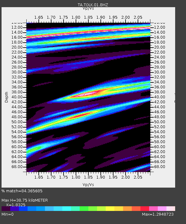
| Estimated Moho Depth: |
38.75 km |
| Estimated Crust Vp/Vs: |
1.83 |
| Assumed Crust Vp: |
6.316 km/s |
| Estimated Crust Vs: |
3.447 km/s |
| Estimated Crust Poisson's Ratio: |
0.29 |
|
| Radial Match: |
84.365685 % |
| Radial Bump: |
400 |
| Transverse Match: |
78.45078 % |
| Transverse Bump: |
400 |
| SOD ConfigId: |
446234 |
| Insert Time: |
2012-08-05 06:04:12.773 +0000 |
| GWidth: |
2.5 |
| Max Bumps: |
400 |
| Tol: |
0.001 |
|

Signal To Noise
| Channel | StoN | STA | LTA |
| TA:TOLK:01:BHZ:20120512T23:39:17.900017Z | 4.5369763 | 1.1673537E-6 | 2.5729773E-7 |
| TA:TOLK:01:BHN:20120512T23:39:17.900017Z | 2.897291 | 5.0141875E-7 | 1.7306469E-7 |
| TA:TOLK:01:BHE:20120512T23:39:17.900017Z | 1.037164 | 2.5822487E-7 | 2.4897207E-7 |
| Arrivals |
| Ps | 5.3 SECOND |
| PpPs | 17 SECOND |
| PsPs/PpSs | 22 SECOND |


