You are here: Home > Network List > TA - USArray Transportable Network (new EarthScope stations) Stations List
> Station F38A Pierce - Schroeder Farm, Trego, WI, USA > Earthquake Result Viewer
F38A Pierce - Schroeder Farm, Trego, WI, USA - Earthquake Result Viewer
| Earthquake location: |
Afghanistan-Tajikistan Bord Reg. |
| Earthquake latitude/longitude: |
38.6/70.4 |
| Earthquake time(UTC): |
2012/05/12 (133) 23:28:43 GMT |
| Earthquake Depth: |
10 km |
| Earthquake Magnitude: |
6.0 MB, 5.7 MS, 5.7 MW, 5.9 MW |
| Earthquake Catalog/Contributor: |
WHDF/NEIC |
|
| Network: |
TA USArray Transportable Network (new EarthScope stations) |
| Station: |
F38A Pierce - Schroeder Farm, Trego, WI, USA |
| Lat/Lon: |
45.96 N/91.88 W |
| Elevation: |
321 m |
|
| Distance: |
94.3 deg |
| Az: |
347.673 deg |
| Baz: |
13.872 deg |
| Ray Param: |
0.041073587 |
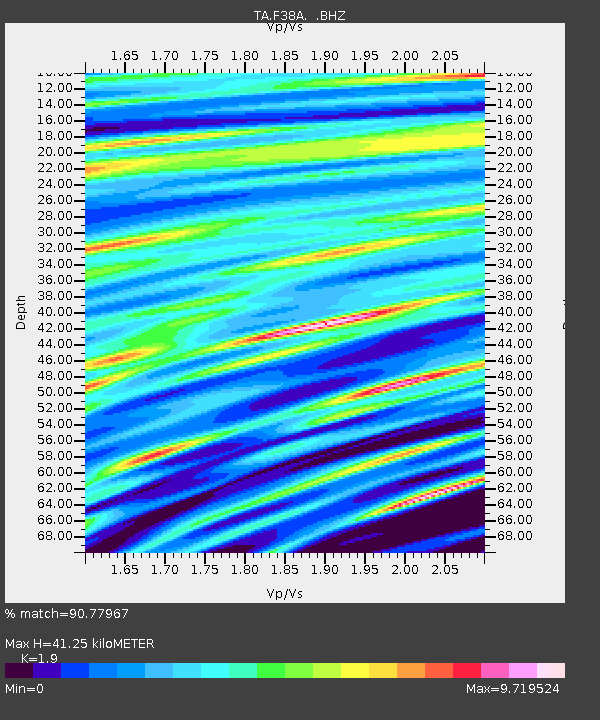
| Estimated Moho Depth: |
41.25 km |
| Estimated Crust Vp/Vs: |
1.90 |
| Assumed Crust Vp: |
6.571 km/s |
| Estimated Crust Vs: |
3.458 km/s |
| Estimated Crust Poisson's Ratio: |
0.31 |
|
| Radial Match: |
90.77967 % |
| Radial Bump: |
400 |
| Transverse Match: |
70.044266 % |
| Transverse Bump: |
400 |
| SOD ConfigId: |
446234 |
| Insert Time: |
2012-08-05 06:04:25.831 +0000 |
| GWidth: |
2.5 |
| Max Bumps: |
400 |
| Tol: |
0.001 |
|

Signal To Noise
| Channel | StoN | STA | LTA |
| TA:F38A: :BHZ:20120512T23:41:31.42498Z | 2.5555966 | 4.2377548E-7 | 1.6582251E-7 |
| TA:F38A: :BHN:20120512T23:41:31.42498Z | 1.3524922 | 6.1039987E-7 | 4.513149E-7 |
| TA:F38A: :BHE:20120512T23:41:31.42498Z | 1.1319197 | 2.531325E-7 | 2.2363112E-7 |
| Arrivals |
| Ps | 5.8 SECOND |
| PpPs | 18 SECOND |
| PsPs/PpSs | 24 SECOND |


