You are here: Home > Network List > G - GEOSCOPE Stations List
> Station MPG Montagne des Peres, French Guyana > Earthquake Result Viewer
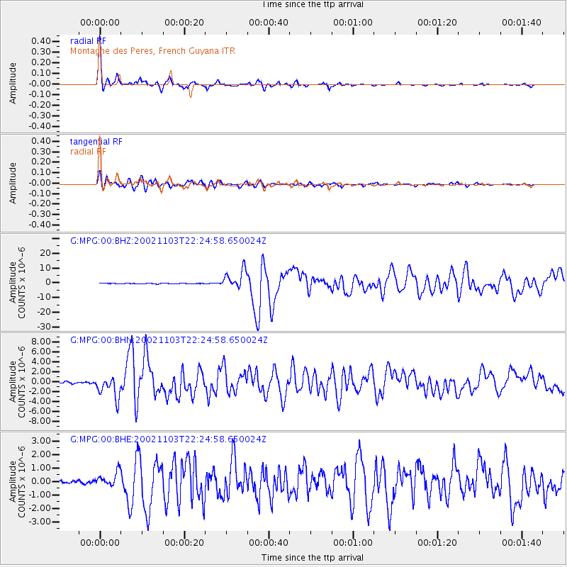
MPG Montagne des Peres, French Guyana - Earthquake Result Viewer

| Earthquake location: |
Central Alaska |
| Earthquake latitude/longitude: |
63.5/-147.4 |
| Earthquake time(UTC): |
2002/11/03 (307) 22:12:41 GMT |
| Earthquake Depth: |
4.9 km |
| Earthquake Magnitude: |
7.0 MB, 8.5 MS, 7.9 MW |
| Earthquake Catalog/Contributor: |
WHDF/NEIC |
|
| Network: |
G GEOSCOPE |
| Station: |
MPG Montagne des Peres, French Guyana |
| Lat/Lon: |
5.11 N/52.64 W |
| Elevation: |
147 m |
|
| Distance: |
87.6 deg |
| Az: |
83.438 deg |
| Baz: |
333.439 deg |
| Ray Param: |
0.04321165 |
| Estimated Moho Depth: |
42.0 km |
| Estimated Crust Vp/Vs: |
1.63 |
| Assumed Crust Vp: |
6.472 km/s |
| Estimated Crust Vs: |
3.977 km/s |
| Estimated Crust Poisson's Ratio: |
0.20 |
|
| Radial Match: |
98.14654 % |
| Radial Bump: |
299 |
| Transverse Match: |
93.014305 % |
| Transverse Bump: |
400 |
| SOD ConfigId: |
4714 |
| Insert Time: |
2010-02-26 23:34:12.053 +0000 |
| GWidth: |
2.5 |
| Max Bumps: |
400 |
| Tol: |
0.001 |
|
Signal To Noise
| Channel | StoN | STA | LTA |
| G:MPG:00:BHN:20021103T22:24:58.650024Z | 21.29756 | 2.2758095E-6 | 1.0685776E-7 |
| G:MPG:00:BHE:20021103T22:24:58.650024Z | 4.265014 | 5.634426E-7 | 1.3210803E-7 |
| G:MPG:00:BHZ:20021103T22:24:58.650024Z | 38.66968 | 6.5219797E-6 | 1.6865873E-7 |
| Arrivals |
| Ps | 4.2 SECOND |
| PpPs | 17 SECOND |
| PsPs/PpSs | 21 SECOND |


