You are here: Home > Network List > G - GEOSCOPE Stations List
> Station MPG Montagne des Peres, French Guyana > Earthquake Result Viewer
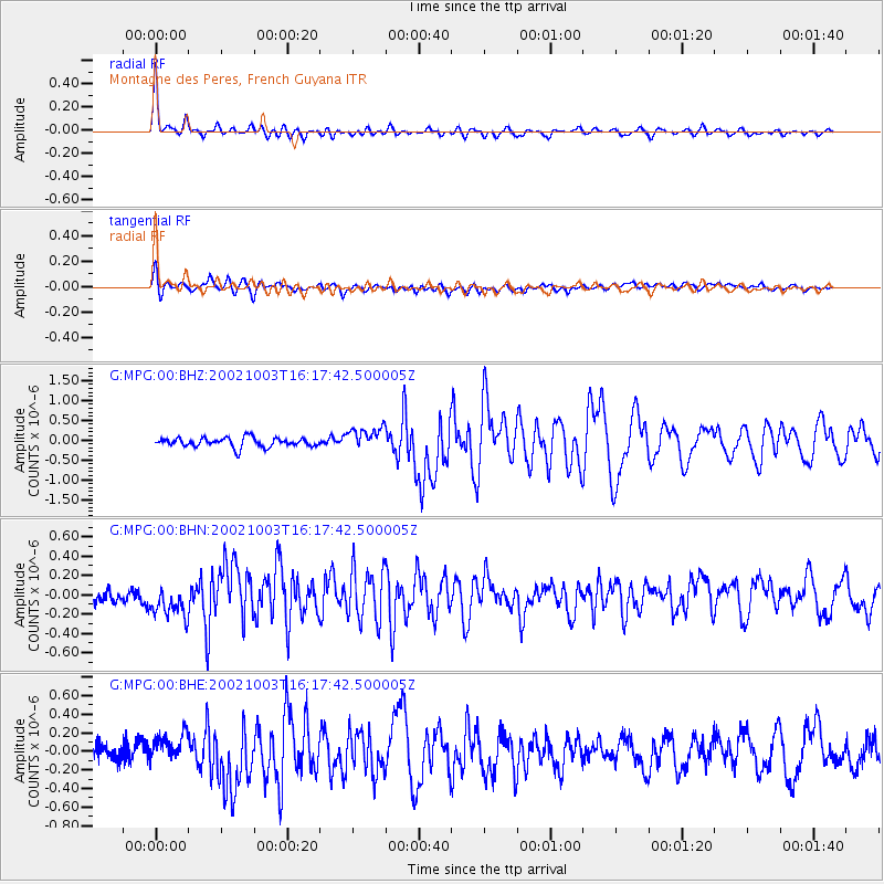
MPG Montagne des Peres, French Guyana - Earthquake Result Viewer

| Earthquake location: |
Gulf Of California |
| Earthquake latitude/longitude: |
23.3/-108.5 |
| Earthquake time(UTC): |
2002/10/03 (276) 16:08:29 GMT |
| Earthquake Depth: |
10 km |
| Earthquake Magnitude: |
5.4 MB, 6.2 MS, 6.5 MW, 6.4 MW |
| Earthquake Catalog/Contributor: |
WHDF/NEIC |
|
| Network: |
G GEOSCOPE |
| Station: |
MPG Montagne des Peres, French Guyana |
| Lat/Lon: |
5.11 N/52.64 W |
| Elevation: |
147 m |
|
| Distance: |
56.7 deg |
| Az: |
99.54 deg |
| Baz: |
294.481 deg |
| Ray Param: |
0.063940704 |
| Estimated Moho Depth: |
40.5 km |
| Estimated Crust Vp/Vs: |
1.70 |
| Assumed Crust Vp: |
6.472 km/s |
| Estimated Crust Vs: |
3.801 km/s |
| Estimated Crust Poisson's Ratio: |
0.24 |
|
| Radial Match: |
89.07633 % |
| Radial Bump: |
400 |
| Transverse Match: |
77.876686 % |
| Transverse Bump: |
400 |
| SOD ConfigId: |
4714 |
| Insert Time: |
2010-02-26 23:34:15.191 +0000 |
| GWidth: |
2.5 |
| Max Bumps: |
400 |
| Tol: |
0.001 |
|
Signal To Noise
| Channel | StoN | STA | LTA |
| G:MPG:00:BHN:20021003T16:17:42.500005Z | 2.1565444 | 1.6720118E-7 | 7.7531986E-8 |
| G:MPG:00:BHE:20021003T16:17:42.500005Z | 1.7867986 | 1.4963483E-7 | 8.374466E-8 |
| G:MPG:00:BHZ:20021003T16:17:42.500005Z | 2.480611 | 2.86834E-7 | 1.1563038E-7 |
| Arrivals |
| Ps | 4.6 SECOND |
| PpPs | 16 SECOND |
| PsPs/PpSs | 21 SECOND |


