You are here: Home > Network List > CI - Caltech Regional Seismic Network Stations List
> Station GSC Goldstone, Goldstone Lake, CA, USA > Earthquake Result Viewer
GSC Goldstone, Goldstone Lake, CA, USA - Earthquake Result Viewer
| Earthquake location: |
Peru-Bolivia Border Region |
| Earthquake latitude/longitude: |
-17.7/-69.6 |
| Earthquake time(UTC): |
2012/05/14 (135) 10:00:40 GMT |
| Earthquake Depth: |
106 km |
| Earthquake Magnitude: |
6.4 MB, 6.2 MW, 6.2 MW |
| Earthquake Catalog/Contributor: |
WHDF/NEIC |
|
| Network: |
CI Caltech Regional Seismic Network |
| Station: |
GSC Goldstone, Goldstone Lake, CA, USA |
| Lat/Lon: |
35.30 N/116.81 W |
| Elevation: |
1000 m |
|
| Distance: |
69.1 deg |
| Az: |
320.03 deg |
| Baz: |
131.518 deg |
| Ray Param: |
0.055571403 |
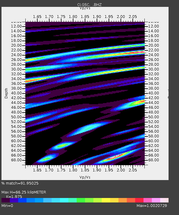
| Estimated Moho Depth: |
66.25 km |
| Estimated Crust Vp/Vs: |
1.98 |
| Assumed Crust Vp: |
6.276 km/s |
| Estimated Crust Vs: |
3.178 km/s |
| Estimated Crust Poisson's Ratio: |
0.33 |
|
| Radial Match: |
91.95025 % |
| Radial Bump: |
400 |
| Transverse Match: |
86.99466 % |
| Transverse Bump: |
400 |
| SOD ConfigId: |
446234 |
| Insert Time: |
2012-08-08 21:47:58.429 +0000 |
| GWidth: |
2.5 |
| Max Bumps: |
400 |
| Tol: |
0.001 |
|
Signal To Noise
| Channel | StoN | STA | LTA |
| CI:GSC: :BHZ:20120514T10:11:04.295002Z | 10.609104 | 9.55071E-7 | 9.002371E-8 |
| CI:GSC: :BHN:20120514T10:11:04.295002Z | 2.3191159 | 2.2395724E-7 | 9.657009E-8 |
| CI:GSC: :BHE:20120514T10:11:04.295002Z | 3.297791 | 3.2481677E-7 | 9.849525E-8 |
| Arrivals |
| Ps | 11 SECOND |
| PpPs | 30 SECOND |
| PsPs/PpSs | 41 SECOND |


