You are here: Home > Network List > CI - Caltech Regional Seismic Network Stations List
> Station GRA Grapevine Ranger Station, Death Valley, CA, USA > Earthquake Result Viewer
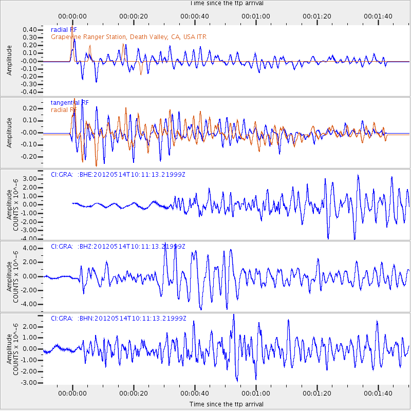
GRA Grapevine Ranger Station, Death Valley, CA, USA - Earthquake Result Viewer
*The percent match for this event was below the threshold and hence no stack was calculated.
| Earthquake location: |
Peru-Bolivia Border Region |
| Earthquake latitude/longitude: |
-17.7/-69.6 |
| Earthquake time(UTC): |
2012/05/14 (135) 10:00:40 GMT |
| Earthquake Depth: |
106 km |
| Earthquake Magnitude: |
6.4 MB, 6.2 MW, 6.2 MW |
| Earthquake Catalog/Contributor: |
WHDF/NEIC |
|
| Network: |
CI Caltech Regional Seismic Network |
| Station: |
GRA Grapevine Ranger Station, Death Valley, CA, USA |
| Lat/Lon: |
37.00 N/117.37 W |
| Elevation: |
689 m |
|
| Distance: |
70.6 deg |
| Az: |
321.057 deg |
| Baz: |
131.543 deg |
| Ray Param: |
$rayparam |
*The percent match for this event was below the threshold and hence was not used in the summary stack. |
|
| Radial Match: |
83.03595 % |
| Radial Bump: |
400 |
| Transverse Match: |
87.44822 % |
| Transverse Bump: |
400 |
| SOD ConfigId: |
446234 |
| Insert Time: |
2012-08-08 21:53:03.089 +0000 |
| GWidth: |
2.5 |
| Max Bumps: |
400 |
| Tol: |
0.001 |
|
Signal To Noise
| Channel | StoN | STA | LTA |
| CI:GRA: :BHZ:20120514T10:11:13.21999Z | 7.1949453 | 8.136795E-7 | 1.1309044E-7 |
| CI:GRA: :BHN:20120514T10:11:13.21999Z | 2.4381988 | 3.7207548E-7 | 1.526026E-7 |
| CI:GRA: :BHE:20120514T10:11:13.21999Z | 1.8875881 | 3.7612278E-7 | 1.9926105E-7 |
| Arrivals |
| Ps | |
| PpPs | |
| PsPs/PpSs | |


