You are here: Home > Network List > IW - Intermountain West Stations List
> Station MOOW Moose Ponds, Wyoming, USA > Earthquake Result Viewer
MOOW Moose Ponds, Wyoming, USA - Earthquake Result Viewer

| Earthquake location: |
Peru-Bolivia Border Region |
| Earthquake latitude/longitude: |
-17.7/-69.6 |
| Earthquake time(UTC): |
2012/05/14 (135) 10:00:40 GMT |
| Earthquake Depth: |
106 km |
| Earthquake Magnitude: |
6.4 MB, 6.2 MW, 6.2 MW |
| Earthquake Catalog/Contributor: |
WHDF/NEIC |
|
| Network: |
IW Intermountain West |
| Station: |
MOOW Moose Ponds, Wyoming, USA |
| Lat/Lon: |
43.75 N/110.74 W |
| Elevation: |
2128 m |
|
| Distance: |
71.8 deg |
| Az: |
329.867 deg |
| Baz: |
138.669 deg |
| Ray Param: |
0.053818643 |
| Estimated Moho Depth: |
19.5 km |
| Estimated Crust Vp/Vs: |
1.81 |
| Assumed Crust Vp: |
6.207 km/s |
| Estimated Crust Vs: |
3.424 km/s |
| Estimated Crust Poisson's Ratio: |
0.28 |
|
| Radial Match: |
92.752975 % |
| Radial Bump: |
400 |
| Transverse Match: |
93.79482 % |
| Transverse Bump: |
400 |
| SOD ConfigId: |
446234 |
| Insert Time: |
2012-08-08 22:00:05.178 +0000 |
| GWidth: |
2.5 |
| Max Bumps: |
400 |
| Tol: |
0.001 |
|
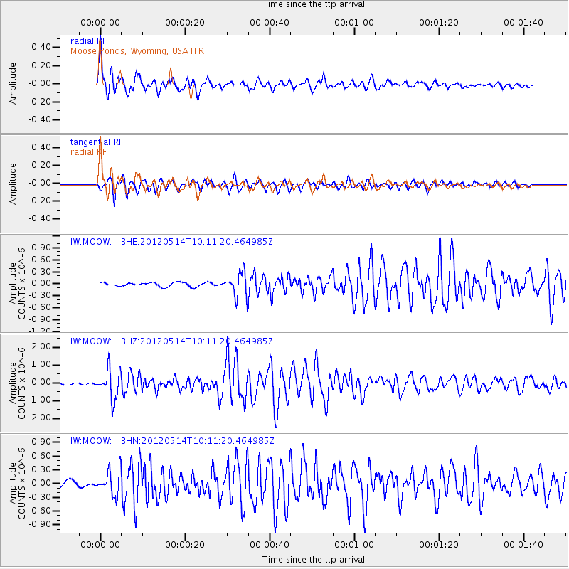
Signal To Noise
| Channel | StoN | STA | LTA |
| IW:MOOW: :BHZ:20120514T10:11:20.464985Z | 17.034203 | 8.0105264E-7 | 4.702613E-8 |
| IW:MOOW: :BHN:20120514T10:11:20.464985Z | 5.5390763 | 2.695831E-7 | 4.866932E-8 |
| IW:MOOW: :BHE:20120514T10:11:20.464985Z | 6.1490197 | 2.991485E-7 | 4.8649788E-8 |
| Arrivals |
| Ps | 2.6 SECOND |
| PpPs | 8.6 SECOND |
| PsPs/PpSs | 11 SECOND |


