You are here: Home > Network List > CI - Caltech Regional Seismic Network Stations List
> Station LGU LGU, Camarillo, CA, USA > Earthquake Result Viewer
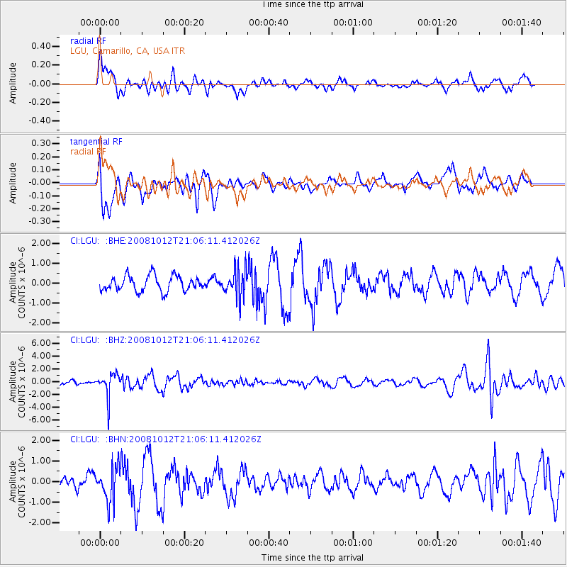
LGU LGU, Camarillo, CA, USA - Earthquake Result Viewer
*The percent match for this event was below the threshold and hence no stack was calculated.
| Earthquake location: |
Southern Bolivia |
| Earthquake latitude/longitude: |
-20.1/-65.0 |
| Earthquake time(UTC): |
2008/10/12 (286) 20:55:41 GMT |
| Earthquake Depth: |
353 km |
| Earthquake Magnitude: |
6.0 MB, 6.2 MW, 6.2 MW |
| Earthquake Catalog/Contributor: |
WHDF/NEIC |
|
| Network: |
CI Caltech Regional Seismic Network |
| Station: |
LGU LGU, Camarillo, CA, USA |
| Lat/Lon: |
34.11 N/119.07 W |
| Elevation: |
416 m |
|
| Distance: |
74.6 deg |
| Az: |
315.793 deg |
| Baz: |
127.845 deg |
| Ray Param: |
$rayparam |
*The percent match for this event was below the threshold and hence was not used in the summary stack. |
|
| Radial Match: |
52.894794 % |
| Radial Bump: |
400 |
| Transverse Match: |
37.4391 % |
| Transverse Bump: |
330 |
| SOD ConfigId: |
2560 |
| Insert Time: |
2010-02-25 20:21:35.219 +0000 |
| GWidth: |
2.5 |
| Max Bumps: |
400 |
| Tol: |
0.001 |
|
Signal To Noise
| Channel | StoN | STA | LTA |
| CI:LGU: :BHZ:20081012T21:06:11.412026Z | 4.996429 | 1.9234378E-6 | 3.849625E-7 |
| CI:LGU: :BHN:20081012T21:06:11.412026Z | 2.613789 | 8.4643267E-7 | 3.2383358E-7 |
| CI:LGU: :BHE:20081012T21:06:11.412026Z | 1.8211999 | 7.01004E-7 | 3.8491328E-7 |
| Arrivals |
| Ps | |
| PpPs | |
| PsPs/PpSs | |


