You are here: Home > Network List > NE - New England Seismic Network Stations List
> Station WES Weston, MA > Earthquake Result Viewer
WES Weston, MA - Earthquake Result Viewer
| Earthquake location: |
Peru-Bolivia Border Region |
| Earthquake latitude/longitude: |
-17.7/-69.6 |
| Earthquake time(UTC): |
2012/05/14 (135) 10:00:40 GMT |
| Earthquake Depth: |
106 km |
| Earthquake Magnitude: |
6.4 MB, 6.2 MW, 6.2 MW |
| Earthquake Catalog/Contributor: |
WHDF/NEIC |
|
| Network: |
NE New England Seismic Network |
| Station: |
WES Weston, MA |
| Lat/Lon: |
42.38 N/71.32 W |
| Elevation: |
60 m |
|
| Distance: |
59.8 deg |
| Az: |
358.516 deg |
| Baz: |
178.09 deg |
| Ray Param: |
0.06165709 |
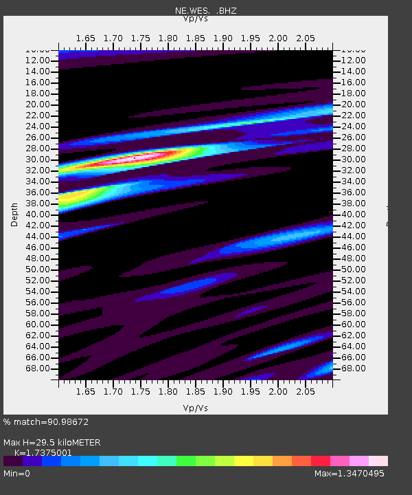
| Estimated Moho Depth: |
29.5 km |
| Estimated Crust Vp/Vs: |
1.74 |
| Assumed Crust Vp: |
6.419 km/s |
| Estimated Crust Vs: |
3.695 km/s |
| Estimated Crust Poisson's Ratio: |
0.25 |
|
| Radial Match: |
90.98672 % |
| Radial Bump: |
322 |
| Transverse Match: |
67.99378 % |
| Transverse Bump: |
400 |
| SOD ConfigId: |
446234 |
| Insert Time: |
2012-08-08 22:03:32.843 +0000 |
| GWidth: |
2.5 |
| Max Bumps: |
400 |
| Tol: |
0.001 |
|

Signal To Noise
| Channel | StoN | STA | LTA |
| NE:WES: :BHZ:20120514T10:10:03.50002Z | 16.691221 | 2.4347648E-6 | 1.4587098E-7 |
| NE:WES: :BHN:20120514T10:10:03.50002Z | 15.811434 | 1.4525995E-6 | 9.187019E-8 |
| NE:WES: :BHE:20120514T10:10:03.50002Z | 1.8482814 | 2.0996782E-7 | 1.1360165E-7 |
| Arrivals |
| Ps | 3.6 SECOND |
| PpPs | 12 SECOND |
| PsPs/PpSs | 16 SECOND |


