You are here: Home > Network List > NE - New England Seismic Network Stations List
> Station WVL Waterville, ME > Earthquake Result Viewer
WVL Waterville, ME - Earthquake Result Viewer
| Earthquake location: |
Peru-Bolivia Border Region |
| Earthquake latitude/longitude: |
-17.7/-69.6 |
| Earthquake time(UTC): |
2012/05/14 (135) 10:00:40 GMT |
| Earthquake Depth: |
106 km |
| Earthquake Magnitude: |
6.4 MB, 6.2 MW, 6.2 MW |
| Earthquake Catalog/Contributor: |
WHDF/NEIC |
|
| Network: |
NE New England Seismic Network |
| Station: |
WVL Waterville, ME |
| Lat/Lon: |
44.56 N/69.66 W |
| Elevation: |
85 m |
|
| Distance: |
61.9 deg |
| Az: |
359.946 deg |
| Baz: |
179.928 deg |
| Ray Param: |
0.06025557 |
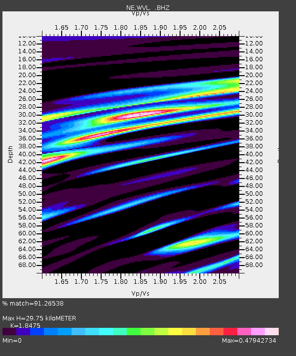
| Estimated Moho Depth: |
29.75 km |
| Estimated Crust Vp/Vs: |
1.85 |
| Assumed Crust Vp: |
6.419 km/s |
| Estimated Crust Vs: |
3.475 km/s |
| Estimated Crust Poisson's Ratio: |
0.29 |
|
| Radial Match: |
91.26538 % |
| Radial Bump: |
305 |
| Transverse Match: |
80.07521 % |
| Transverse Bump: |
400 |
| SOD ConfigId: |
446234 |
| Insert Time: |
2012-08-08 22:04:08.625 +0000 |
| GWidth: |
2.5 |
| Max Bumps: |
400 |
| Tol: |
0.001 |
|

Signal To Noise
| Channel | StoN | STA | LTA |
| NE:WVL: :BHZ:20120514T10:10:18.070027Z | 26.075191 | 3.0932692E-6 | 1.1862882E-7 |
| NE:WVL: :BHN:20120514T10:10:18.070027Z | 11.862648 | 1.39376E-6 | 1.1749148E-7 |
| NE:WVL: :BHE:20120514T10:10:18.070027Z | 1.5590274 | 1.3468566E-7 | 8.639082E-8 |
| Arrivals |
| Ps | 4.1 SECOND |
| PpPs | 13 SECOND |
| PsPs/PpSs | 17 SECOND |


