You are here: Home > Network List > NE - New England Seismic Network Stations List
> Station PQI Presque Isle, ME > Earthquake Result Viewer
PQI Presque Isle, ME - Earthquake Result Viewer
| Earthquake location: |
Peru-Bolivia Border Region |
| Earthquake latitude/longitude: |
-17.7/-69.6 |
| Earthquake time(UTC): |
2012/05/14 (135) 10:00:40 GMT |
| Earthquake Depth: |
106 km |
| Earthquake Magnitude: |
6.4 MB, 6.2 MW, 6.2 MW |
| Earthquake Catalog/Contributor: |
WHDF/NEIC |
|
| Network: |
NE New England Seismic Network |
| Station: |
PQI Presque Isle, ME |
| Lat/Lon: |
46.67 N/68.01 W |
| Elevation: |
175 m |
|
| Distance: |
64.1 deg |
| Az: |
1.208 deg |
| Baz: |
181.673 deg |
| Ray Param: |
0.058881074 |
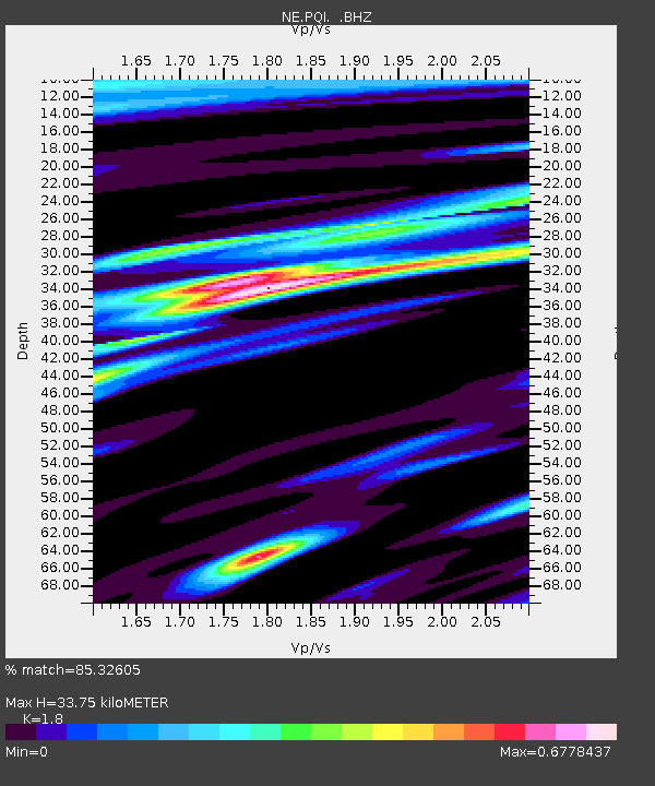
| Estimated Moho Depth: |
33.75 km |
| Estimated Crust Vp/Vs: |
1.80 |
| Assumed Crust Vp: |
6.419 km/s |
| Estimated Crust Vs: |
3.566 km/s |
| Estimated Crust Poisson's Ratio: |
0.28 |
|
| Radial Match: |
85.32605 % |
| Radial Bump: |
380 |
| Transverse Match: |
83.67017 % |
| Transverse Bump: |
400 |
| SOD ConfigId: |
446234 |
| Insert Time: |
2012-08-08 22:04:15.427 +0000 |
| GWidth: |
2.5 |
| Max Bumps: |
400 |
| Tol: |
0.001 |
|
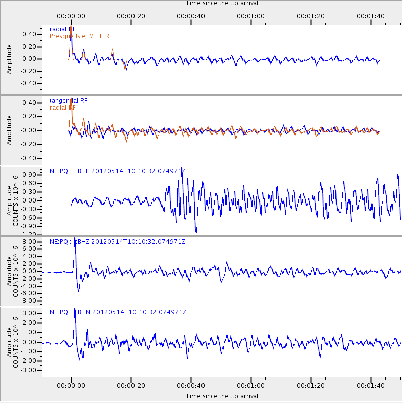
Signal To Noise
| Channel | StoN | STA | LTA |
| NE:PQI: :BHZ:20120514T10:10:32.074971Z | 45.311924 | 3.2831217E-6 | 7.2456025E-8 |
| NE:PQI: :BHN:20120514T10:10:32.074971Z | 16.680588 | 1.2984372E-6 | 7.784121E-8 |
| NE:PQI: :BHE:20120514T10:10:32.074971Z | 3.524351 | 2.9173924E-7 | 8.277815E-8 |
| Arrivals |
| Ps | 4.4 SECOND |
| PpPs | 14 SECOND |
| PsPs/PpSs | 19 SECOND |


