You are here: Home > Network List > G - GEOSCOPE Stations List
> Station MPG Montagne des Peres, French Guyana > Earthquake Result Viewer
MPG Montagne des Peres, French Guyana - Earthquake Result Viewer
| Earthquake location: |
Caribbean Sea |
| Earthquake latitude/longitude: |
16.1/-87.5 |
| Earthquake time(UTC): |
2005/09/23 (266) 13:48:31 GMT |
| Earthquake Depth: |
30 km |
| Earthquake Magnitude: |
5.9 MB, 5.4 MS, 5.9 MW, 5.9 MW |
| Earthquake Catalog/Contributor: |
WHDF/NEIC |
|
| Network: |
G GEOSCOPE |
| Station: |
MPG Montagne des Peres, French Guyana |
| Lat/Lon: |
5.11 N/52.64 W |
| Elevation: |
147 m |
|
| Distance: |
35.9 deg |
| Az: |
103.886 deg |
| Baz: |
290.494 deg |
| Ray Param: |
0.07692648 |
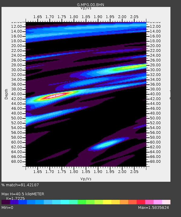
| Estimated Moho Depth: |
40.5 km |
| Estimated Crust Vp/Vs: |
1.72 |
| Assumed Crust Vp: |
6.472 km/s |
| Estimated Crust Vs: |
3.757 km/s |
| Estimated Crust Poisson's Ratio: |
0.25 |
|
| Radial Match: |
91.42187 % |
| Radial Bump: |
330 |
| Transverse Match: |
84.41422 % |
| Transverse Bump: |
400 |
| SOD ConfigId: |
2564 |
| Insert Time: |
2010-02-26 23:34:44.647 +0000 |
| GWidth: |
2.5 |
| Max Bumps: |
400 |
| Tol: |
0.001 |
|
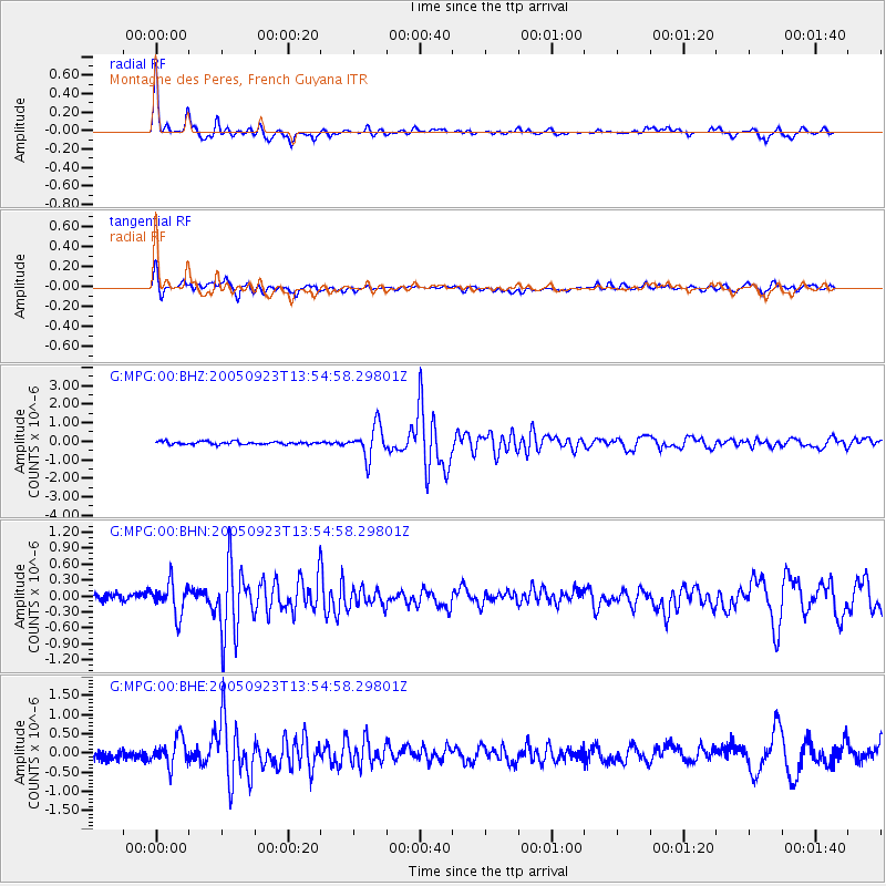
Signal To Noise
| Channel | StoN | STA | LTA |
| G:MPG:00:BHN:20050923T13:54:58.29801Z | 3.6639752 | 2.986341E-7 | 8.150548E-8 |
| G:MPG:00:BHE:20050923T13:54:58.29801Z | 3.3377466 | 3.5354213E-7 | 1.059224E-7 |
| G:MPG:00:BHZ:20050923T13:54:58.29801Z | 11.478786 | 8.4200354E-7 | 7.335301E-8 |
| Arrivals |
| Ps | 4.9 SECOND |
| PpPs | 16 SECOND |
| PsPs/PpSs | 21 SECOND |


