You are here: Home > Network List > G - GEOSCOPE Stations List
> Station MPG Montagne des Peres, French Guyana > Earthquake Result Viewer
MPG Montagne des Peres, French Guyana - Earthquake Result Viewer
| Earthquake location: |
Nicaragua |
| Earthquake latitude/longitude: |
11.2/-85.5 |
| Earthquake time(UTC): |
2005/08/03 (215) 11:03:15 GMT |
| Earthquake Depth: |
14 km |
| Earthquake Magnitude: |
6.0 MB, 6.5 MS, 6.3 MW, 6.3 MW |
| Earthquake Catalog/Contributor: |
WHDF/NEIC |
|
| Network: |
G GEOSCOPE |
| Station: |
MPG Montagne des Peres, French Guyana |
| Lat/Lon: |
5.11 N/52.64 W |
| Elevation: |
147 m |
|
| Distance: |
33.1 deg |
| Az: |
97.921 deg |
| Baz: |
282.706 deg |
| Ray Param: |
0.07835152 |
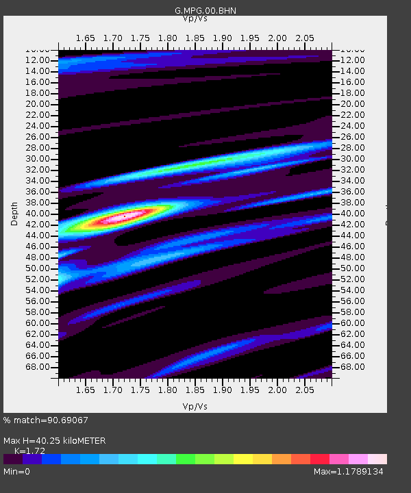
| Estimated Moho Depth: |
40.25 km |
| Estimated Crust Vp/Vs: |
1.72 |
| Assumed Crust Vp: |
6.472 km/s |
| Estimated Crust Vs: |
3.763 km/s |
| Estimated Crust Poisson's Ratio: |
0.24 |
|
| Radial Match: |
90.69067 % |
| Radial Bump: |
351 |
| Transverse Match: |
70.72895 % |
| Transverse Bump: |
400 |
| SOD ConfigId: |
2564 |
| Insert Time: |
2010-02-26 23:34:46.192 +0000 |
| GWidth: |
2.5 |
| Max Bumps: |
400 |
| Tol: |
0.001 |
|
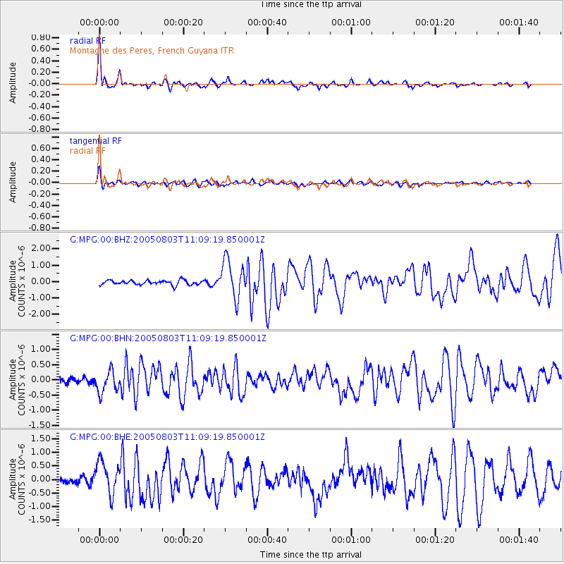
Signal To Noise
| Channel | StoN | STA | LTA |
| G:MPG:00:BHN:20050803T11:09:19.850001Z | 5.0261016 | 3.6935324E-7 | 7.348703E-8 |
| G:MPG:00:BHE:20050803T11:09:19.850001Z | 6.2788773 | 6.1586456E-7 | 9.808514E-8 |
| G:MPG:00:BHZ:20050803T11:09:19.850001Z | 8.661315 | 1.1838221E-6 | 1.3667925E-7 |
| Arrivals |
| Ps | 4.9 SECOND |
| PpPs | 16 SECOND |
| PsPs/PpSs | 20 SECOND |


