You are here: Home > Network List > NM - Cooperative New Madrid Seismic Network Stations List
> Station UALR University of Arkansas, Little Rock > Earthquake Result Viewer
UALR University of Arkansas, Little Rock - Earthquake Result Viewer
| Earthquake location: |
Peru-Bolivia Border Region |
| Earthquake latitude/longitude: |
-17.7/-69.6 |
| Earthquake time(UTC): |
2012/05/14 (135) 10:00:40 GMT |
| Earthquake Depth: |
106 km |
| Earthquake Magnitude: |
6.4 MB, 6.2 MW, 6.2 MW |
| Earthquake Catalog/Contributor: |
WHDF/NEIC |
|
| Network: |
NM Cooperative New Madrid Seismic Network |
| Station: |
UALR University of Arkansas, Little Rock |
| Lat/Lon: |
34.78 N/92.34 W |
| Elevation: |
138 m |
|
| Distance: |
56.5 deg |
| Az: |
337.548 deg |
| Baz: |
153.748 deg |
| Ray Param: |
0.06379932 |
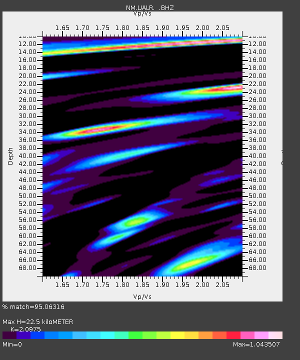
| Estimated Moho Depth: |
22.5 km |
| Estimated Crust Vp/Vs: |
2.10 |
| Assumed Crust Vp: |
6.498 km/s |
| Estimated Crust Vs: |
3.098 km/s |
| Estimated Crust Poisson's Ratio: |
0.35 |
|
| Radial Match: |
95.06316 % |
| Radial Bump: |
400 |
| Transverse Match: |
86.13304 % |
| Transverse Bump: |
400 |
| SOD ConfigId: |
446234 |
| Insert Time: |
2012-08-08 22:05:13.098 +0000 |
| GWidth: |
2.5 |
| Max Bumps: |
400 |
| Tol: |
0.001 |
|

Signal To Noise
| Channel | StoN | STA | LTA |
| NM:UALR: :BHZ:20120514T10:09:40.495015Z | 50.45659 | 4.027402E-6 | 7.981916E-8 |
| NM:UALR: :BHN:20120514T10:09:40.495015Z | 14.187341 | 1.5069772E-6 | 1.0621985E-7 |
| NM:UALR: :BHE:20120514T10:09:40.495015Z | 13.177666 | 7.56223E-7 | 5.7386718E-8 |
| Arrivals |
| Ps | 4.0 SECOND |
| PpPs | 10 SECOND |
| PsPs/PpSs | 14 SECOND |


