You are here: Home > Network List > OK - Oklahoma Seismic Network Stations List
> Station U32A Winter Ranch, Mooreland, OK, USA > Earthquake Result Viewer
U32A Winter Ranch, Mooreland, OK, USA - Earthquake Result Viewer
| Earthquake location: |
Peru-Bolivia Border Region |
| Earthquake latitude/longitude: |
-17.7/-69.6 |
| Earthquake time(UTC): |
2012/05/14 (135) 10:00:40 GMT |
| Earthquake Depth: |
106 km |
| Earthquake Magnitude: |
6.4 MB, 6.2 MW, 6.2 MW |
| Earthquake Catalog/Contributor: |
WHDF/NEIC |
|
| Network: |
OK Oklahoma Seismic Network |
| Station: |
U32A Winter Ranch, Mooreland, OK, USA |
| Lat/Lon: |
36.38 N/99.00 W |
| Elevation: |
525 m |
|
| Distance: |
60.5 deg |
| Az: |
332.923 deg |
| Baz: |
147.47 deg |
| Ray Param: |
0.061165754 |
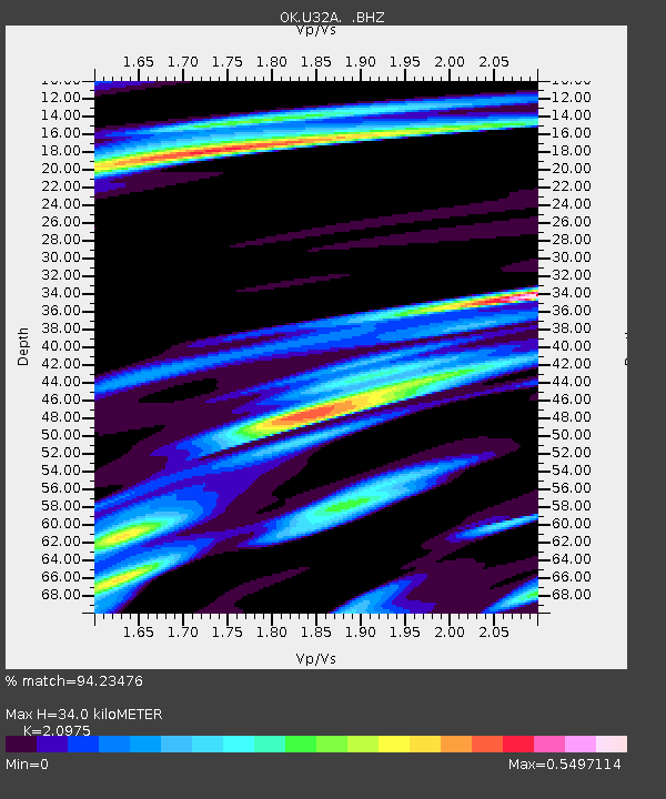
| Estimated Moho Depth: |
34.0 km |
| Estimated Crust Vp/Vs: |
2.10 |
| Assumed Crust Vp: |
6.426 km/s |
| Estimated Crust Vs: |
3.064 km/s |
| Estimated Crust Poisson's Ratio: |
0.35 |
|
| Radial Match: |
94.23476 % |
| Radial Bump: |
400 |
| Transverse Match: |
85.82695 % |
| Transverse Bump: |
400 |
| SOD ConfigId: |
446234 |
| Insert Time: |
2012-08-08 22:06:28.209 +0000 |
| GWidth: |
2.5 |
| Max Bumps: |
400 |
| Tol: |
0.001 |
|

Signal To Noise
| Channel | StoN | STA | LTA |
| OK:U32A: :BHZ:20120514T10:10:08.599995Z | 34.677654 | 4.014494E-6 | 1.1576603E-7 |
| OK:U32A: :BHN:20120514T10:10:08.599995Z | 13.846938 | 1.5858125E-6 | 1.1452441E-7 |
| OK:U32A: :BHE:20120514T10:10:08.599995Z | 8.72791 | 1.2023504E-6 | 1.3775924E-7 |
| Arrivals |
| Ps | 6.0 SECOND |
| PpPs | 16 SECOND |
| PsPs/PpSs | 22 SECOND |


