You are here: Home > Network List > TA - USArray Transportable Network (new EarthScope stations) Stations List
> Station 109C Camp Elliot, Mirimar, CA, USA > Earthquake Result Viewer
109C Camp Elliot, Mirimar, CA, USA - Earthquake Result Viewer
| Earthquake location: |
Peru-Bolivia Border Region |
| Earthquake latitude/longitude: |
-17.7/-69.6 |
| Earthquake time(UTC): |
2012/05/14 (135) 10:00:40 GMT |
| Earthquake Depth: |
106 km |
| Earthquake Magnitude: |
6.4 MB, 6.2 MW, 6.2 MW |
| Earthquake Catalog/Contributor: |
WHDF/NEIC |
|
| Network: |
TA USArray Transportable Network (new EarthScope stations) |
| Station: |
109C Camp Elliot, Mirimar, CA, USA |
| Lat/Lon: |
32.89 N/117.11 W |
| Elevation: |
150 m |
|
| Distance: |
67.7 deg |
| Az: |
317.903 deg |
| Baz: |
130.57 deg |
| Ray Param: |
0.056480527 |
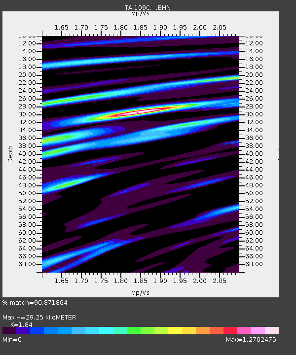
| Estimated Moho Depth: |
29.25 km |
| Estimated Crust Vp/Vs: |
1.84 |
| Assumed Crust Vp: |
6.264 km/s |
| Estimated Crust Vs: |
3.404 km/s |
| Estimated Crust Poisson's Ratio: |
0.29 |
|
| Radial Match: |
90.871864 % |
| Radial Bump: |
378 |
| Transverse Match: |
80.950035 % |
| Transverse Bump: |
377 |
| SOD ConfigId: |
446234 |
| Insert Time: |
2012-08-08 22:08:27.751 +0000 |
| GWidth: |
2.5 |
| Max Bumps: |
400 |
| Tol: |
0.001 |
|

Signal To Noise
| Channel | StoN | STA | LTA |
| TA:109C: :BHZ:20120514T10:10:55.670002Z | 5.865502 | 6.131111E-7 | 1.0452833E-7 |
| TA:109C: :BHN:20120514T10:10:55.670002Z | 1.4631432 | 2.0553075E-7 | 1.4047207E-7 |
| TA:109C: :BHE:20120514T10:10:55.670002Z | 2.0898092 | 3.024478E-7 | 1.4472508E-7 |
| Arrivals |
| Ps | 4.1 SECOND |
| PpPs | 13 SECOND |
| PsPs/PpSs | 17 SECOND |


