You are here: Home > Network List > TA - USArray Transportable Network (new EarthScope stations) Stations List
> Station N23A Red Feather Lakes, CO, USA > Earthquake Result Viewer
N23A Red Feather Lakes, CO, USA - Earthquake Result Viewer
| Earthquake location: |
Peru-Bolivia Border Region |
| Earthquake latitude/longitude: |
-17.7/-69.6 |
| Earthquake time(UTC): |
2012/05/14 (135) 10:00:40 GMT |
| Earthquake Depth: |
106 km |
| Earthquake Magnitude: |
6.4 MB, 6.2 MW, 6.2 MW |
| Earthquake Catalog/Contributor: |
WHDF/NEIC |
|
| Network: |
TA USArray Transportable Network (new EarthScope stations) |
| Station: |
N23A Red Feather Lakes, CO, USA |
| Lat/Lon: |
40.89 N/105.94 W |
| Elevation: |
2458 m |
|
| Distance: |
67.3 deg |
| Az: |
330.86 deg |
| Baz: |
142.238 deg |
| Ray Param: |
0.056744985 |
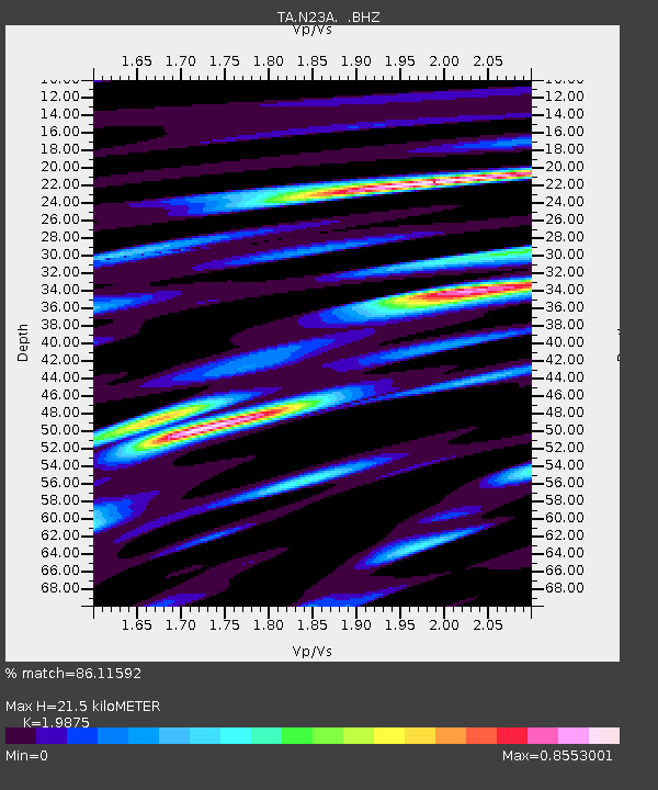
| Estimated Moho Depth: |
21.5 km |
| Estimated Crust Vp/Vs: |
1.99 |
| Assumed Crust Vp: |
6.306 km/s |
| Estimated Crust Vs: |
3.173 km/s |
| Estimated Crust Poisson's Ratio: |
0.33 |
|
| Radial Match: |
86.11592 % |
| Radial Bump: |
400 |
| Transverse Match: |
86.83486 % |
| Transverse Bump: |
400 |
| SOD ConfigId: |
446234 |
| Insert Time: |
2012-08-08 22:09:59.392 +0000 |
| GWidth: |
2.5 |
| Max Bumps: |
400 |
| Tol: |
0.001 |
|
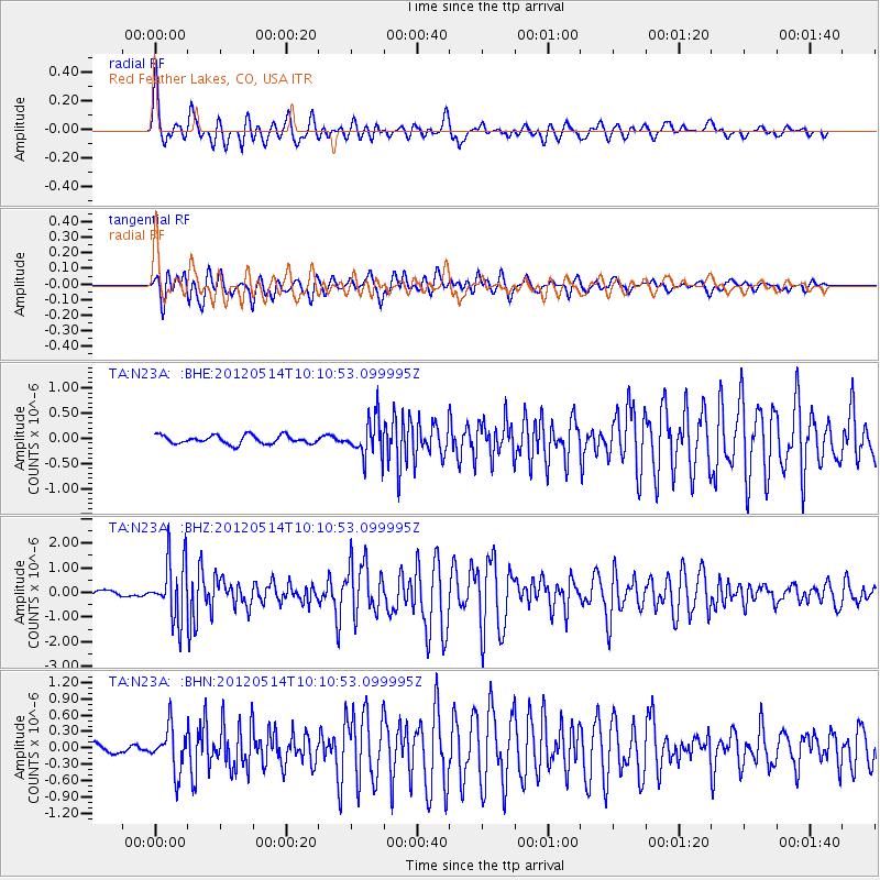
Signal To Noise
| Channel | StoN | STA | LTA |
| TA:N23A: :BHZ:20120514T10:10:53.099995Z | 11.802808 | 1.2002362E-6 | 1.0169073E-7 |
| TA:N23A: :BHN:20120514T10:10:53.099995Z | 4.9258957 | 3.9617598E-7 | 8.042719E-8 |
| TA:N23A: :BHE:20120514T10:10:53.099995Z | 4.537772 | 3.7340558E-7 | 8.22883E-8 |
| Arrivals |
| Ps | 3.5 SECOND |
| PpPs | 9.8 SECOND |
| PsPs/PpSs | 13 SECOND |


