You are here: Home > Network List > G - GEOSCOPE Stations List
> Station NOUC Port Laguerre, New Caledonia > Earthquake Result Viewer
NOUC Port Laguerre, New Caledonia - Earthquake Result Viewer
| Earthquake location: |
Kuril Islands |
| Earthquake latitude/longitude: |
45.9/151.3 |
| Earthquake time(UTC): |
1995/04/17 (107) 23:28:08 GMT |
| Earthquake Depth: |
34 km |
| Earthquake Magnitude: |
6.1 MB, 6.3 MS, 6.2 UNKNOWN, 6.8 MW |
| Earthquake Catalog/Contributor: |
WHDF/NEIC |
|
| Network: |
G GEOSCOPE |
| Station: |
NOUC Port Laguerre, New Caledonia |
| Lat/Lon: |
22.10 S/166.30 E |
| Elevation: |
112 m |
|
| Distance: |
69.0 deg |
| Az: |
165.091 deg |
| Baz: |
348.83 deg |
| Ray Param: |
0.05585624 |
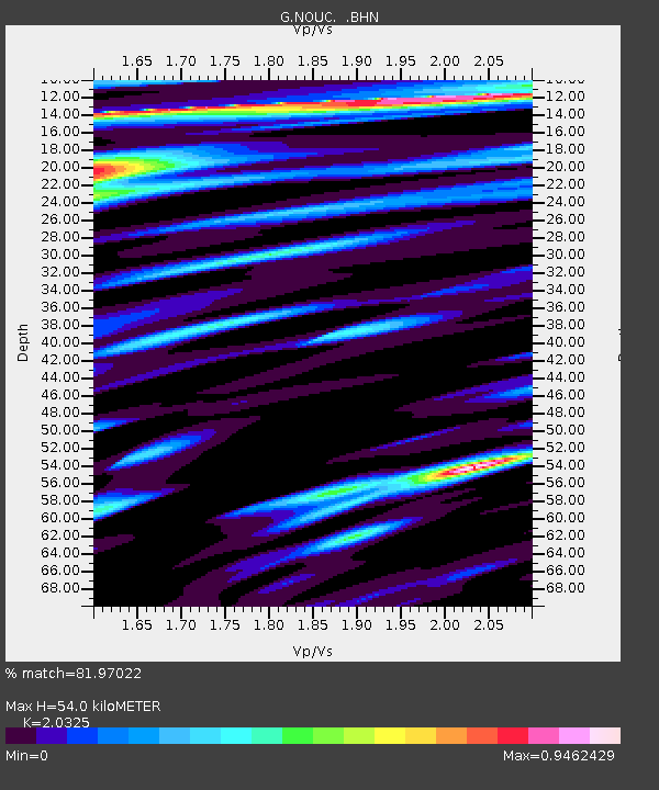
| Estimated Moho Depth: |
54.0 km |
| Estimated Crust Vp/Vs: |
2.03 |
| Assumed Crust Vp: |
5.14 km/s |
| Estimated Crust Vs: |
2.529 km/s |
| Estimated Crust Poisson's Ratio: |
0.34 |
|
| Radial Match: |
81.97022 % |
| Radial Bump: |
400 |
| Transverse Match: |
61.327396 % |
| Transverse Bump: |
400 |
| SOD ConfigId: |
4480 |
| Insert Time: |
2010-02-26 23:34:53.029 +0000 |
| GWidth: |
2.5 |
| Max Bumps: |
400 |
| Tol: |
0.001 |
|

Signal To Noise
| Channel | StoN | STA | LTA |
| G:NOUC: :BHN:19950417T23:38:39.692029Z | 4.1475844 | 1.3110323E-6 | 3.160954E-7 |
| G:NOUC: :BHE:19950417T23:38:39.692029Z | 0.8334974 | 3.0841554E-7 | 3.700258E-7 |
| G:NOUC: :BHZ:19950417T23:38:39.692029Z | 1.0733664 | 3.90353E-7 | 3.6367172E-7 |
| Arrivals |
| Ps | 11 SECOND |
| PpPs | 31 SECOND |
| PsPs/PpSs | 42 SECOND |


