You are here: Home > Network List > TA - USArray Transportable Network (new EarthScope stations) Stations List
> Station G03D McMinnville, OR, USA > Earthquake Result Viewer
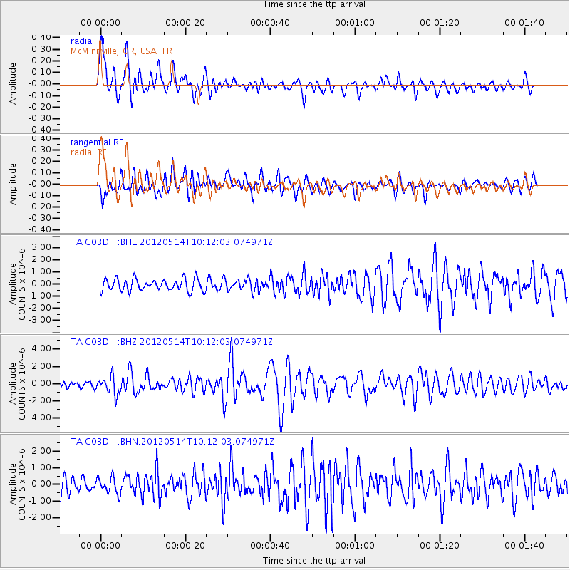
G03D McMinnville, OR, USA - Earthquake Result Viewer
*The percent match for this event was below the threshold and hence no stack was calculated.
| Earthquake location: |
Peru-Bolivia Border Region |
| Earthquake latitude/longitude: |
-17.7/-69.6 |
| Earthquake time(UTC): |
2012/05/14 (135) 10:00:40 GMT |
| Earthquake Depth: |
106 km |
| Earthquake Magnitude: |
6.4 MB, 6.2 MW, 6.2 MW |
| Earthquake Catalog/Contributor: |
WHDF/NEIC |
|
| Network: |
TA USArray Transportable Network (new EarthScope stations) |
| Station: |
G03D McMinnville, OR, USA |
| Lat/Lon: |
45.21 N/123.26 W |
| Elevation: |
222 m |
|
| Distance: |
79.3 deg |
| Az: |
324.579 deg |
| Baz: |
128.585 deg |
| Ray Param: |
$rayparam |
*The percent match for this event was below the threshold and hence was not used in the summary stack. |
|
| Radial Match: |
78.74152 % |
| Radial Bump: |
400 |
| Transverse Match: |
62.644875 % |
| Transverse Bump: |
400 |
| SOD ConfigId: |
446234 |
| Insert Time: |
2012-08-08 22:11:31.543 +0000 |
| GWidth: |
2.5 |
| Max Bumps: |
400 |
| Tol: |
0.001 |
|
Signal To Noise
| Channel | StoN | STA | LTA |
| TA:G03D: :BHZ:20120514T10:12:03.074971Z | 2.3321006 | 9.983835E-7 | 4.2810478E-7 |
| TA:G03D: :BHN:20120514T10:12:03.074971Z | 0.8990348 | 4.8036793E-7 | 5.343151E-7 |
| TA:G03D: :BHE:20120514T10:12:03.074971Z | 0.8782073 | 4.194555E-7 | 4.7762694E-7 |
| Arrivals |
| Ps | |
| PpPs | |
| PsPs/PpSs | |


