You are here: Home > Network List > TA - USArray Transportable Network (new EarthScope stations) Stations List
> Station H32A Carlson Farm, Erwin, SD, USA > Earthquake Result Viewer
H32A Carlson Farm, Erwin, SD, USA - Earthquake Result Viewer
| Earthquake location: |
Peru-Bolivia Border Region |
| Earthquake latitude/longitude: |
-17.7/-69.6 |
| Earthquake time(UTC): |
2012/05/14 (135) 10:00:40 GMT |
| Earthquake Depth: |
106 km |
| Earthquake Magnitude: |
6.4 MB, 6.2 MW, 6.2 MW |
| Earthquake Catalog/Contributor: |
WHDF/NEIC |
|
| Network: |
TA USArray Transportable Network (new EarthScope stations) |
| Station: |
H32A Carlson Farm, Erwin, SD, USA |
| Lat/Lon: |
44.50 N/97.44 W |
| Elevation: |
573 m |
|
| Distance: |
66.9 deg |
| Az: |
338.693 deg |
| Baz: |
151.045 deg |
| Ray Param: |
0.057031546 |
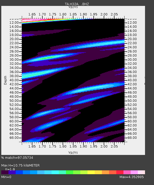
| Estimated Moho Depth: |
10.75 km |
| Estimated Crust Vp/Vs: |
1.60 |
| Assumed Crust Vp: |
6.552 km/s |
| Estimated Crust Vs: |
4.095 km/s |
| Estimated Crust Poisson's Ratio: |
0.18 |
|
| Radial Match: |
97.05734 % |
| Radial Bump: |
400 |
| Transverse Match: |
87.96328 % |
| Transverse Bump: |
400 |
| SOD ConfigId: |
446234 |
| Insert Time: |
2012-08-08 22:13:22.251 +0000 |
| GWidth: |
2.5 |
| Max Bumps: |
400 |
| Tol: |
0.001 |
|

Signal To Noise
| Channel | StoN | STA | LTA |
| TA:H32A: :BHZ:20120514T10:10:50.324971Z | 61.87216 | 5.313712E-6 | 8.588211E-8 |
| TA:H32A: :BHN:20120514T10:10:50.324971Z | 19.017244 | 4.316114E-6 | 2.269579E-7 |
| TA:H32A: :BHE:20120514T10:10:50.324971Z | 18.275534 | 2.1773617E-6 | 1.191408E-7 |
| Arrivals |
| Ps | 1.0 SECOND |
| PpPs | 4.1 SECOND |
| PsPs/PpSs | 5.1 SECOND |


