You are here: Home > Network List > G - GEOSCOPE Stations List
> Station NOUC Port Laguerre, New Caledonia > Earthquake Result Viewer
NOUC Port Laguerre, New Caledonia - Earthquake Result Viewer
| Earthquake location: |
Banda Sea |
| Earthquake latitude/longitude: |
-4.2/127.3 |
| Earthquake time(UTC): |
2000/08/28 (241) 19:29:24 GMT |
| Earthquake Depth: |
33 km |
| Earthquake Magnitude: |
6.0 MB |
| Earthquake Catalog/Contributor: |
WHDF/NEIC |
|
| Network: |
G GEOSCOPE |
| Station: |
NOUC Port Laguerre, New Caledonia |
| Lat/Lon: |
22.10 S/166.30 E |
| Elevation: |
112 m |
|
| Distance: |
41.8 deg |
| Az: |
118.825 deg |
| Baz: |
289.571 deg |
| Ray Param: |
0.07351766 |
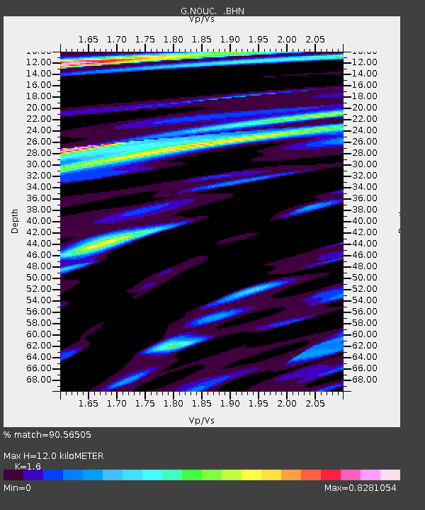
| Estimated Moho Depth: |
12.0 km |
| Estimated Crust Vp/Vs: |
1.60 |
| Assumed Crust Vp: |
5.14 km/s |
| Estimated Crust Vs: |
3.212 km/s |
| Estimated Crust Poisson's Ratio: |
0.18 |
|
| Radial Match: |
90.56505 % |
| Radial Bump: |
349 |
| Transverse Match: |
82.50086 % |
| Transverse Bump: |
400 |
| SOD ConfigId: |
3744 |
| Insert Time: |
2010-02-26 23:35:01.456 +0000 |
| GWidth: |
2.5 |
| Max Bumps: |
400 |
| Tol: |
0.001 |
|
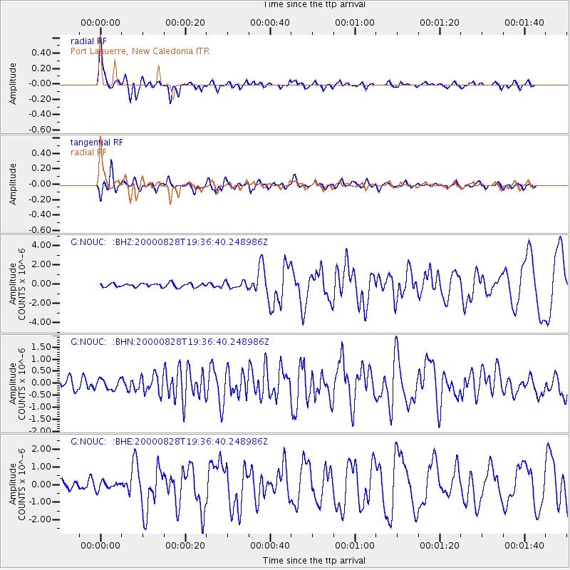
Signal To Noise
| Channel | StoN | STA | LTA |
| G:NOUC: :BHN:20000828T19:36:40.248986Z | 1.0658984 | 2.1767846E-7 | 2.0422064E-7 |
| G:NOUC: :BHE:20000828T19:36:40.248986Z | 0.70043045 | 2.0980119E-7 | 2.995318E-7 |
| G:NOUC: :BHZ:20000828T19:36:40.248986Z | 1.8045307 | 3.3913457E-7 | 1.8793506E-7 |
| Arrivals |
| Ps | 1.5 SECOND |
| PpPs | 5.8 SECOND |
| PsPs/PpSs | 7.3 SECOND |


