You are here: Home > Network List > TA - USArray Transportable Network (new EarthScope stations) Stations List
> Station SUSD Miller, SD, USA > Earthquake Result Viewer
SUSD Miller, SD, USA - Earthquake Result Viewer
| Earthquake location: |
Peru-Bolivia Border Region |
| Earthquake latitude/longitude: |
-17.7/-69.6 |
| Earthquake time(UTC): |
2012/05/14 (135) 10:00:40 GMT |
| Earthquake Depth: |
106 km |
| Earthquake Magnitude: |
6.4 MB, 6.2 MW, 6.2 MW |
| Earthquake Catalog/Contributor: |
WHDF/NEIC |
|
| Network: |
TA USArray Transportable Network (new EarthScope stations) |
| Station: |
SUSD Miller, SD, USA |
| Lat/Lon: |
44.44 N/98.96 W |
| Elevation: |
520 m |
|
| Distance: |
67.4 deg |
| Az: |
337.635 deg |
| Baz: |
149.573 deg |
| Ray Param: |
0.056716908 |
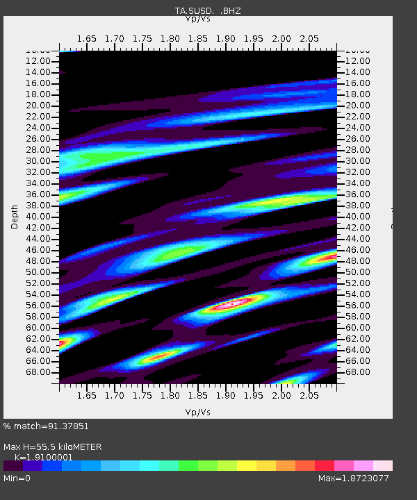
| Estimated Moho Depth: |
55.5 km |
| Estimated Crust Vp/Vs: |
1.91 |
| Assumed Crust Vp: |
6.53 km/s |
| Estimated Crust Vs: |
3.419 km/s |
| Estimated Crust Poisson's Ratio: |
0.31 |
|
| Radial Match: |
91.37851 % |
| Radial Bump: |
400 |
| Transverse Match: |
69.61131 % |
| Transverse Bump: |
400 |
| SOD ConfigId: |
446234 |
| Insert Time: |
2012-08-08 22:15:46.899 +0000 |
| GWidth: |
2.5 |
| Max Bumps: |
400 |
| Tol: |
0.001 |
|

Signal To Noise
| Channel | StoN | STA | LTA |
| TA:SUSD: :BHZ:20120514T10:10:53.37502Z | 26.285433 | 3.7835232E-6 | 1.4393993E-7 |
| TA:SUSD: :BHN:20120514T10:10:53.37502Z | 18.760056 | 1.9352597E-6 | 1.0315852E-7 |
| TA:SUSD: :BHE:20120514T10:10:53.37502Z | 7.791336 | 1.0710787E-6 | 1.3747048E-7 |
| Arrivals |
| Ps | 8.0 SECOND |
| PpPs | 24 SECOND |
| PsPs/PpSs | 32 SECOND |


