You are here: Home > Network List > G - GEOSCOPE Stations List
> Station NOUC Port Laguerre, New Caledonia > Earthquake Result Viewer
NOUC Port Laguerre, New Caledonia - Earthquake Result Viewer
| Earthquake location: |
South Indian Ocean |
| Earthquake latitude/longitude: |
-13.8/97.5 |
| Earthquake time(UTC): |
2000/06/18 (170) 14:44:13 GMT |
| Earthquake Depth: |
10 km |
| Earthquake Magnitude: |
6.8 MB, 7.8 MS, 7.8 MW, 7.6 MW |
| Earthquake Catalog/Contributor: |
WHDF/NEIC |
|
| Network: |
G GEOSCOPE |
| Station: |
NOUC Port Laguerre, New Caledonia |
| Lat/Lon: |
22.10 S/166.30 E |
| Elevation: |
112 m |
|
| Distance: |
65.6 deg |
| Az: |
108.183 deg |
| Baz: |
264.407 deg |
| Ray Param: |
0.05819239 |
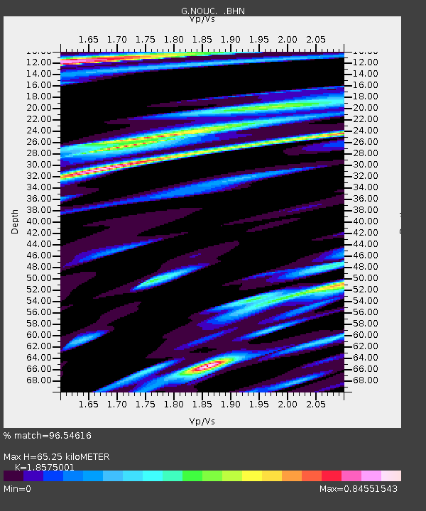
| Estimated Moho Depth: |
65.25 km |
| Estimated Crust Vp/Vs: |
1.86 |
| Assumed Crust Vp: |
5.14 km/s |
| Estimated Crust Vs: |
2.767 km/s |
| Estimated Crust Poisson's Ratio: |
0.30 |
|
| Radial Match: |
96.54616 % |
| Radial Bump: |
400 |
| Transverse Match: |
93.959465 % |
| Transverse Bump: |
400 |
| SOD ConfigId: |
3744 |
| Insert Time: |
2010-02-26 23:35:04.655 +0000 |
| GWidth: |
2.5 |
| Max Bumps: |
400 |
| Tol: |
0.001 |
|

Signal To Noise
| Channel | StoN | STA | LTA |
| G:NOUC: :BHN:20000618T14:54:25.849001Z | 0.8308625 | 2.9044244E-7 | 3.4956742E-7 |
| G:NOUC: :BHE:20000618T14:54:25.849001Z | 2.9186404 | 1.3204997E-6 | 4.5243658E-7 |
| G:NOUC: :BHZ:20000618T14:54:25.849001Z | 3.4498887 | 2.1842318E-6 | 6.3313104E-7 |
| Arrivals |
| Ps | 11 SECOND |
| PpPs | 35 SECOND |
| PsPs/PpSs | 47 SECOND |


