You are here: Home > Network List > TA - USArray Transportable Network (new EarthScope stations) Stations List
> Station G36A St. Michael, MN, USA > Earthquake Result Viewer
G36A St. Michael, MN, USA - Earthquake Result Viewer
| Earthquake location: |
Peru-Bolivia Border Region |
| Earthquake latitude/longitude: |
-17.7/-69.6 |
| Earthquake time(UTC): |
2012/05/14 (135) 10:00:40 GMT |
| Earthquake Depth: |
106 km |
| Earthquake Magnitude: |
6.4 MB, 6.2 MW, 6.2 MW |
| Earthquake Catalog/Contributor: |
WHDF/NEIC |
|
| Network: |
TA USArray Transportable Network (new EarthScope stations) |
| Station: |
G36A St. Michael, MN, USA |
| Lat/Lon: |
45.23 N/93.75 W |
| Elevation: |
293 m |
|
| Distance: |
66.4 deg |
| Az: |
341.597 deg |
| Baz: |
154.789 deg |
| Ray Param: |
0.05738727 |
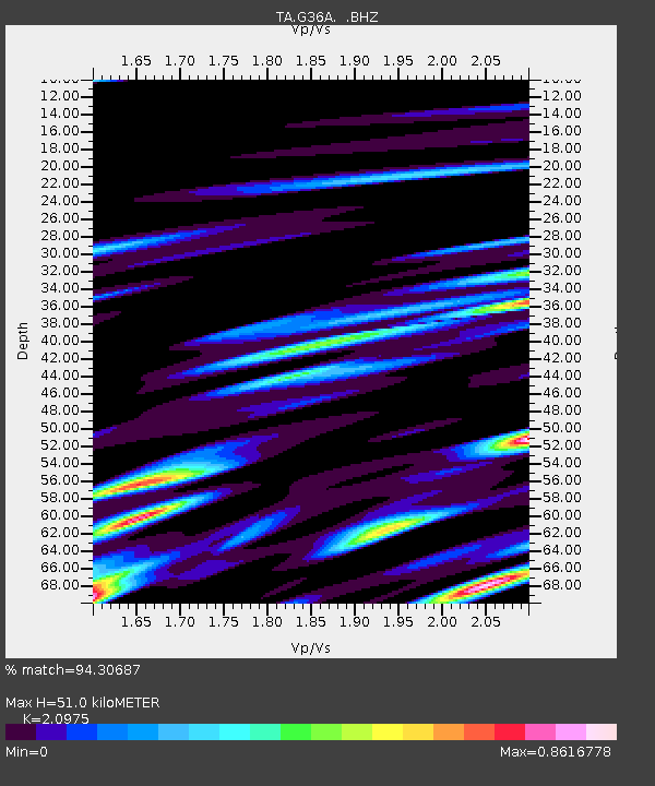
| Estimated Moho Depth: |
51.0 km |
| Estimated Crust Vp/Vs: |
2.10 |
| Assumed Crust Vp: |
6.571 km/s |
| Estimated Crust Vs: |
3.133 km/s |
| Estimated Crust Poisson's Ratio: |
0.35 |
|
| Radial Match: |
94.30687 % |
| Radial Bump: |
400 |
| Transverse Match: |
87.52959 % |
| Transverse Bump: |
400 |
| SOD ConfigId: |
446234 |
| Insert Time: |
2012-08-08 22:17:23.021 +0000 |
| GWidth: |
2.5 |
| Max Bumps: |
400 |
| Tol: |
0.001 |
|
Signal To Noise
| Channel | StoN | STA | LTA |
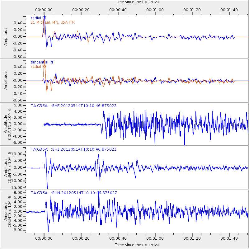
| TA:G36A: :BHZ:20120514T10:10:46.87502Z | 49.810272 | 5.9039307E-6 | 1.18528376E-7 |
| TA:G36A: :BHN:20120514T10:10:46.87502Z | 24.033249 | 3.344766E-6 | 1.3917244E-7 |
| TA:G36A: :BHE:20120514T10:10:46.87502Z | 13.70004 | 1.8396929E-6 | 1.3428377E-7 |
| Arrivals |
| Ps | 8.8 SECOND |
| PpPs | 23 SECOND |
| PsPs/PpSs | 32 SECOND |


