You are here: Home > Network List > G - GEOSCOPE Stations List
> Station NOUC Port Laguerre, New Caledonia > Earthquake Result Viewer
NOUC Port Laguerre, New Caledonia - Earthquake Result Viewer

| Earthquake location: |
West Of Macquarie Island |
| Earthquake latitude/longitude: |
-60.2/149.9 |
| Earthquake time(UTC): |
2000/03/04 (064) 02:24:22 GMT |
| Earthquake Depth: |
10 km |
| Earthquake Magnitude: |
5.5 MB, 6.2 MS, 6.4 MW, 6.3 MW |
| Earthquake Catalog/Contributor: |
WHDF/NEIC |
|
| Network: |
G GEOSCOPE |
| Station: |
NOUC Port Laguerre, New Caledonia |
| Lat/Lon: |
22.10 S/166.30 E |
| Elevation: |
112 m |
|
| Distance: |
39.8 deg |
| Az: |
24.219 deg |
| Baz: |
192.778 deg |
| Ray Param: |
0.07479626 |
| Estimated Moho Depth: |
67.25 km |
| Estimated Crust Vp/Vs: |
2.06 |
| Assumed Crust Vp: |
5.14 km/s |
| Estimated Crust Vs: |
2.501 km/s |
| Estimated Crust Poisson's Ratio: |
0.34 |
|
| Radial Match: |
83.643005 % |
| Radial Bump: |
324 |
| Transverse Match: |
60.715755 % |
| Transverse Bump: |
400 |
| SOD ConfigId: |
3744 |
| Insert Time: |
2010-02-26 23:35:09.685 +0000 |
| GWidth: |
2.5 |
| Max Bumps: |
400 |
| Tol: |
0.001 |
|
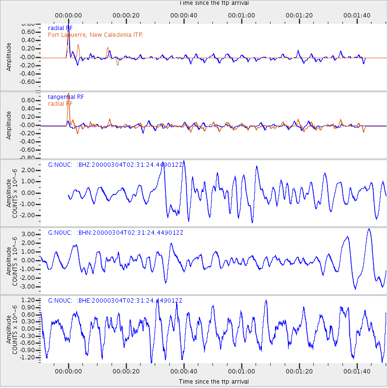
Signal To Noise
| Channel | StoN | STA | LTA |
| G:NOUC: :BHN:20000304T02:31:24.449012Z | 2.3794055 | 1.1837789E-6 | 4.9751037E-7 |
| G:NOUC: :BHE:20000304T02:31:24.449012Z | 0.95593756 | 4.6339318E-7 | 4.8475255E-7 |
| G:NOUC: :BHZ:20000304T02:31:24.449012Z | 4.009635 | 1.5648337E-6 | 3.9026838E-7 |
| Arrivals |
| Ps | 14 SECOND |
| PpPs | 38 SECOND |
| PsPs/PpSs | 53 SECOND |


