You are here: Home > Network List > TA - USArray Transportable Network (new EarthScope stations) Stations List
> Station C34A RKJ Ranch, Bemidji, MN, USA > Earthquake Result Viewer
C34A RKJ Ranch, Bemidji, MN, USA - Earthquake Result Viewer
| Earthquake location: |
Peru-Bolivia Border Region |
| Earthquake latitude/longitude: |
-17.7/-69.6 |
| Earthquake time(UTC): |
2012/05/14 (135) 10:00:40 GMT |
| Earthquake Depth: |
106 km |
| Earthquake Magnitude: |
6.4 MB, 6.2 MW, 6.2 MW |
| Earthquake Catalog/Contributor: |
WHDF/NEIC |
|
| Network: |
TA USArray Transportable Network (new EarthScope stations) |
| Station: |
C34A RKJ Ranch, Bemidji, MN, USA |
| Lat/Lon: |
47.65 N/94.91 W |
| Elevation: |
441 m |
|
| Distance: |
68.9 deg |
| Az: |
341.942 deg |
| Baz: |
154.082 deg |
| Ray Param: |
0.055743277 |
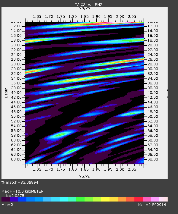
| Estimated Moho Depth: |
10.0 km |
| Estimated Crust Vp/Vs: |
2.04 |
| Assumed Crust Vp: |
6.419 km/s |
| Estimated Crust Vs: |
3.151 km/s |
| Estimated Crust Poisson's Ratio: |
0.34 |
|
| Radial Match: |
83.66994 % |
| Radial Bump: |
400 |
| Transverse Match: |
80.70682 % |
| Transverse Bump: |
400 |
| SOD ConfigId: |
446234 |
| Insert Time: |
2012-08-08 22:19:48.704 +0000 |
| GWidth: |
2.5 |
| Max Bumps: |
400 |
| Tol: |
0.001 |
|
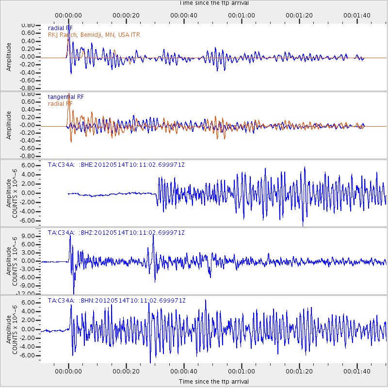
Signal To Noise
| Channel | StoN | STA | LTA |
| TA:C34A: :BHZ:20120514T10:11:02.699971Z | 52.925495 | 4.192648E-6 | 7.9217926E-8 |
| TA:C34A: :BHN:20120514T10:11:02.699971Z | 11.4677725 | 2.4885721E-6 | 2.1700572E-7 |
| TA:C34A: :BHE:20120514T10:11:02.699971Z | 8.600172 | 1.8636164E-6 | 2.1669526E-7 |
| Arrivals |
| Ps | 1.7 SECOND |
| PpPs | 4.6 SECOND |
| PsPs/PpSs | 6.2 SECOND |


