You are here: Home > Network List > TA - USArray Transportable Network (new EarthScope stations) Stations List
> Station L38A Oak Wood Farm, Albion, IA, USA > Earthquake Result Viewer
L38A Oak Wood Farm, Albion, IA, USA - Earthquake Result Viewer

| Earthquake location: |
Peru-Bolivia Border Region |
| Earthquake latitude/longitude: |
-17.7/-69.6 |
| Earthquake time(UTC): |
2012/05/14 (135) 10:00:40 GMT |
| Earthquake Depth: |
106 km |
| Earthquake Magnitude: |
6.4 MB, 6.2 MW, 6.2 MW |
| Earthquake Catalog/Contributor: |
WHDF/NEIC |
|
| Network: |
TA USArray Transportable Network (new EarthScope stations) |
| Station: |
L38A Oak Wood Farm, Albion, IA, USA |
| Lat/Lon: |
42.14 N/92.96 W |
| Elevation: |
300 m |
|
| Distance: |
63.3 deg |
| Az: |
340.721 deg |
| Baz: |
154.961 deg |
| Ray Param: |
0.059368853 |
| Estimated Moho Depth: |
14.5 km |
| Estimated Crust Vp/Vs: |
1.92 |
| Assumed Crust Vp: |
6.53 km/s |
| Estimated Crust Vs: |
3.401 km/s |
| Estimated Crust Poisson's Ratio: |
0.31 |
|
| Radial Match: |
86.91786 % |
| Radial Bump: |
400 |
| Transverse Match: |
75.39812 % |
| Transverse Bump: |
400 |
| SOD ConfigId: |
446234 |
| Insert Time: |
2012-08-08 22:21:16.719 +0000 |
| GWidth: |
2.5 |
| Max Bumps: |
400 |
| Tol: |
0.001 |
|
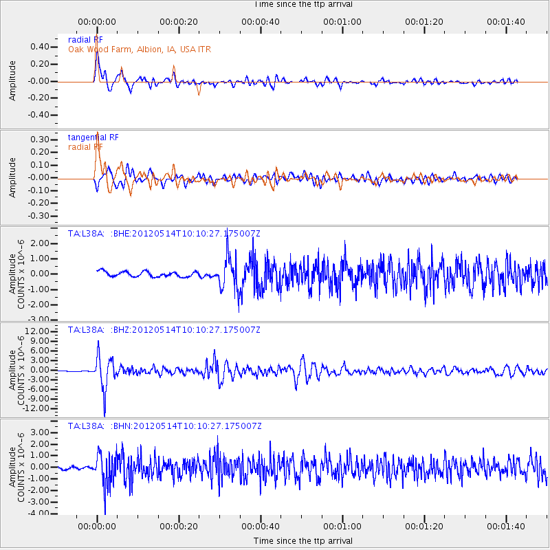
Signal To Noise
| Channel | StoN | STA | LTA |
| TA:L38A: :BHZ:20120514T10:10:27.175007Z | 47.455887 | 4.954364E-6 | 1.0439936E-7 |
| TA:L38A: :BHN:20120514T10:10:27.175007Z | 15.716039 | 1.3756973E-6 | 8.75346E-8 |
| TA:L38A: :BHE:20120514T10:10:27.175007Z | 6.400407 | 1.0684446E-6 | 1.6693386E-7 |
| Arrivals |
| Ps | 2.1 SECOND |
| PpPs | 6.2 SECOND |
| PsPs/PpSs | 8.4 SECOND |


