You are here: Home > Network List > CI - Caltech Regional Seismic Network Stations List
> Station LGU LGU, Camarillo, CA, USA > Earthquake Result Viewer
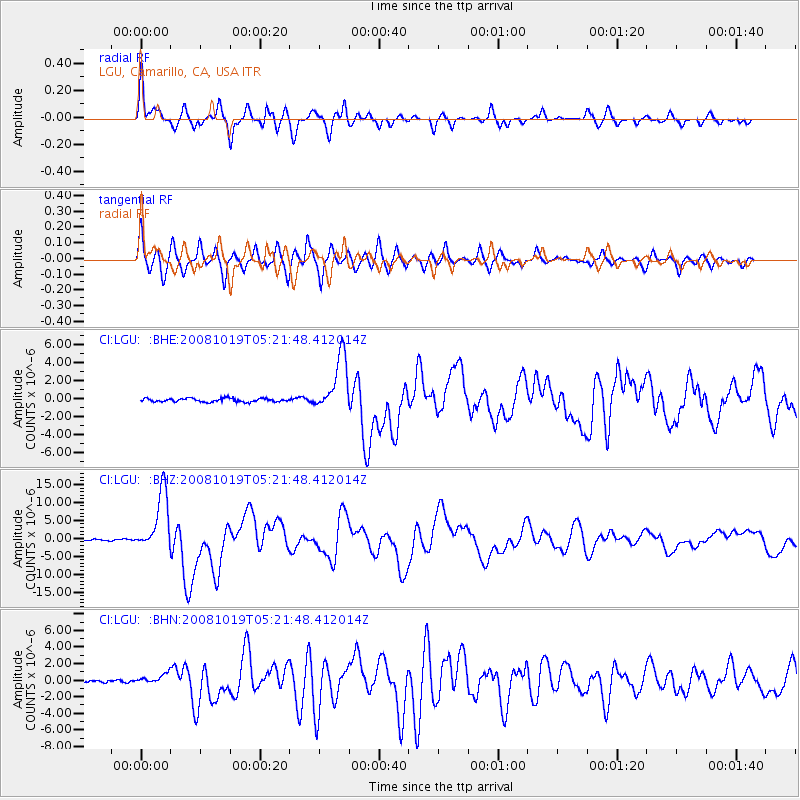
LGU LGU, Camarillo, CA, USA - Earthquake Result Viewer
*The percent match for this event was below the threshold and hence no stack was calculated.
| Earthquake location: |
Tonga Islands |
| Earthquake latitude/longitude: |
-21.9/-173.8 |
| Earthquake time(UTC): |
2008/10/19 (293) 05:10:33 GMT |
| Earthquake Depth: |
29 km |
| Earthquake Magnitude: |
6.8 MB, 7.0 MS, 6.9 MW, 6.9 MW |
| Earthquake Catalog/Contributor: |
WHDF/NEIC |
|
| Network: |
CI Caltech Regional Seismic Network |
| Station: |
LGU LGU, Camarillo, CA, USA |
| Lat/Lon: |
34.11 N/119.07 W |
| Elevation: |
416 m |
|
| Distance: |
76.2 deg |
| Az: |
44.242 deg |
| Baz: |
231.362 deg |
| Ray Param: |
$rayparam |
*The percent match for this event was below the threshold and hence was not used in the summary stack. |
|
| Radial Match: |
92.35964 % |
| Radial Bump: |
378 |
| Transverse Match: |
89.169334 % |
| Transverse Bump: |
400 |
| SOD ConfigId: |
2560 |
| Insert Time: |
2010-02-25 20:21:37.354 +0000 |
| GWidth: |
2.5 |
| Max Bumps: |
400 |
| Tol: |
0.001 |
|
Signal To Noise
| Channel | StoN | STA | LTA |
| CI:LGU: :BHZ:20081019T05:21:48.412014Z | 41.425117 | 8.254204E-6 | 1.9925602E-7 |
| CI:LGU: :BHN:20081019T05:21:48.412014Z | 1.8584548 | 5.7022515E-7 | 3.0682756E-7 |
| CI:LGU: :BHE:20081019T05:21:48.412014Z | 16.222166 | 3.0683113E-6 | 1.8914315E-7 |
| Arrivals |
| Ps | |
| PpPs | |
| PsPs/PpSs | |


