You are here: Home > Network List > G - GEOSCOPE Stations List
> Station NOUC Port Laguerre, New Caledonia > Earthquake Result Viewer
NOUC Port Laguerre, New Caledonia - Earthquake Result Viewer
| Earthquake location: |
Balleny Islands Region |
| Earthquake latitude/longitude: |
-61.6/154.7 |
| Earthquake time(UTC): |
1995/06/21 (172) 15:28:51 GMT |
| Earthquake Depth: |
10 km |
| Earthquake Magnitude: |
5.6 MB, 6.7 MS, 6.8 UNKNOWN, 6.8 MW |
| Earthquake Catalog/Contributor: |
WHDF/NEIC |
|
| Network: |
G GEOSCOPE |
| Station: |
NOUC Port Laguerre, New Caledonia |
| Lat/Lon: |
22.10 S/166.30 E |
| Elevation: |
112 m |
|
| Distance: |
40.3 deg |
| Az: |
16.741 deg |
| Baz: |
188.534 deg |
| Ray Param: |
0.07447691 |
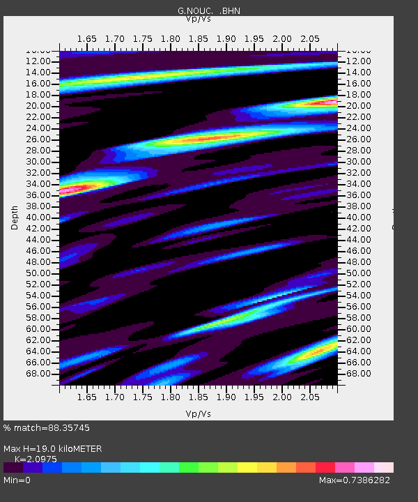
| Estimated Moho Depth: |
19.0 km |
| Estimated Crust Vp/Vs: |
2.10 |
| Assumed Crust Vp: |
5.14 km/s |
| Estimated Crust Vs: |
2.451 km/s |
| Estimated Crust Poisson's Ratio: |
0.35 |
|
| Radial Match: |
88.35745 % |
| Radial Bump: |
332 |
| Transverse Match: |
66.91404 % |
| Transverse Bump: |
400 |
| SOD ConfigId: |
4480 |
| Insert Time: |
2010-02-26 23:35:18.089 +0000 |
| GWidth: |
2.5 |
| Max Bumps: |
400 |
| Tol: |
0.001 |
|

Signal To Noise
| Channel | StoN | STA | LTA |
| G:NOUC: :BHN:19950621T15:35:57.845007Z | 3.7414541 | 1.7173801E-6 | 4.5901405E-7 |
| G:NOUC: :BHE:19950621T15:35:57.845007Z | 1.1991194 | 8.972506E-7 | 7.482579E-7 |
| G:NOUC: :BHZ:19950621T15:35:57.845007Z | 1.5222799 | 5.4236614E-7 | 3.5628543E-7 |
| Arrivals |
| Ps | 4.2 SECOND |
| PpPs | 11 SECOND |
| PsPs/PpSs | 15 SECOND |


