You are here: Home > Network List > G - GEOSCOPE Stations List
> Station NOUC Port Laguerre, New Caledonia > Earthquake Result Viewer
NOUC Port Laguerre, New Caledonia - Earthquake Result Viewer
| Earthquake location: |
Halmahera, Indonesia |
| Earthquake latitude/longitude: |
-1.6/127.4 |
| Earthquake time(UTC): |
1995/06/28 (179) 21:14:49 GMT |
| Earthquake Depth: |
33 km |
| Earthquake Magnitude: |
5.6 MB, 5.4 MS, 5.9 UNKNOWN |
| Earthquake Catalog/Contributor: |
WHDF/NEIC |
|
| Network: |
G GEOSCOPE |
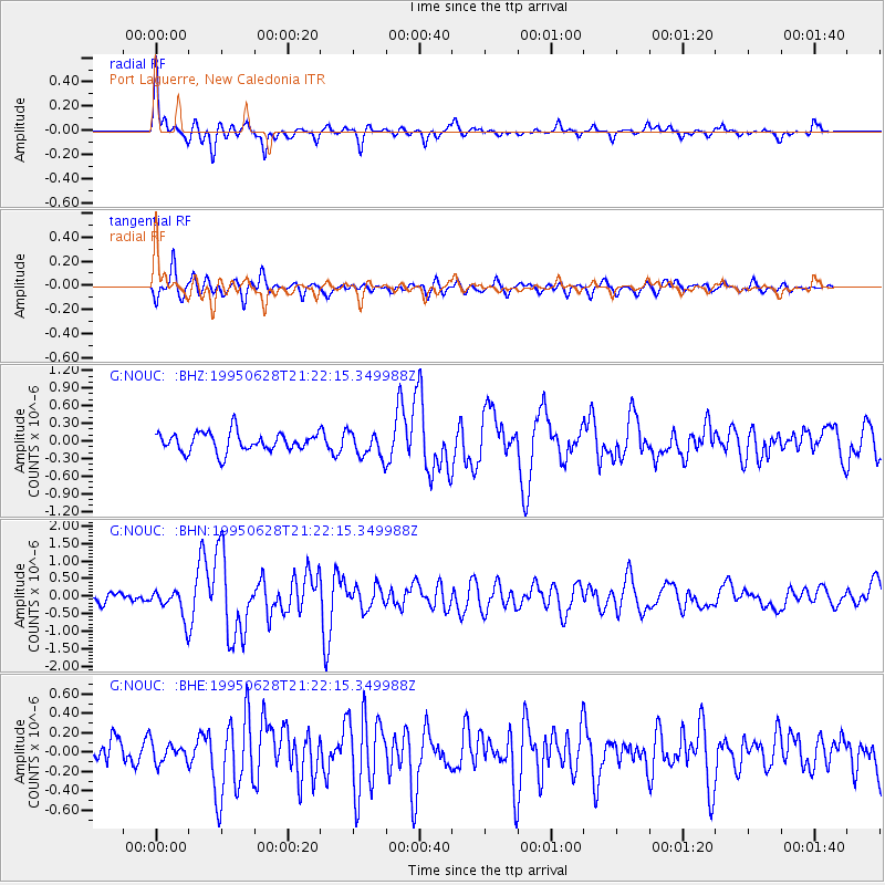
| Station: |
NOUC Port Laguerre, New Caledonia |
| Lat/Lon: |
22.10 S/166.30 E |
| Elevation: |
112 m |
|
| Distance: |
43.0 deg |
| Az: |
121.252 deg |
| Baz: |
292.86 deg |
| Ray Param: |
0.07277707 |
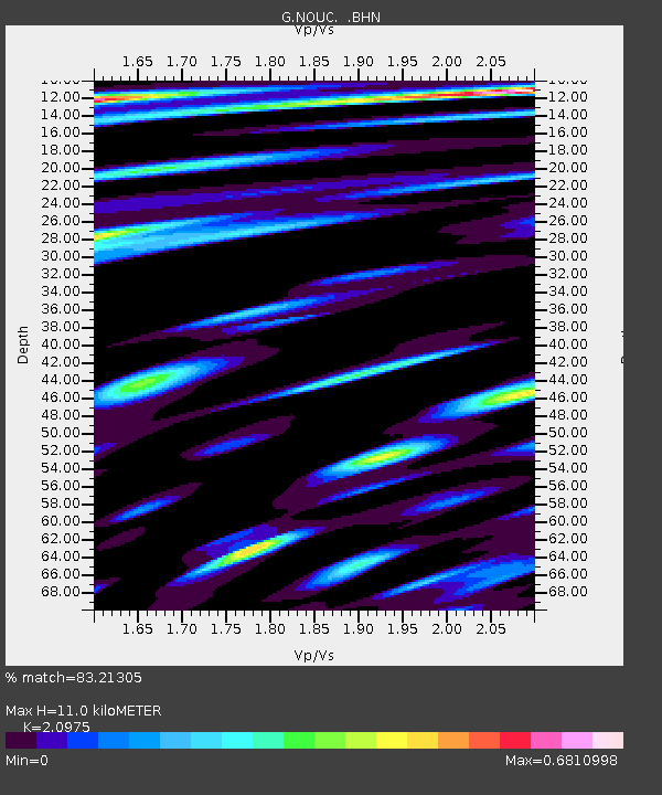
| Estimated Moho Depth: |
11.0 km |
| Estimated Crust Vp/Vs: |
2.10 |
| Assumed Crust Vp: |
5.14 km/s |
| Estimated Crust Vs: |
2.451 km/s |
| Estimated Crust Poisson's Ratio: |
0.35 |
|
| Radial Match: |
83.21305 % |
| Radial Bump: |
317 |
| Transverse Match: |
73.31858 % |
| Transverse Bump: |
400 |
| SOD ConfigId: |
4480 |
| Insert Time: |
2010-02-26 23:35:19.194 +0000 |
| GWidth: |
2.5 |
| Max Bumps: |
400 |
| Tol: |
0.001 |
|
Signal To Noise
| Channel | StoN | STA | LTA |
| G:NOUC: :BHN:19950628T21:22:15.349988Z | 2.3732264 | 4.235448E-7 | 1.7846793E-7 |
| G:NOUC: :BHE:19950628T21:22:15.349988Z | 0.5973054 | 9.8434185E-8 | 1.6479709E-7 |
| G:NOUC: :BHZ:19950628T21:22:15.349988Z | 1.3687487 | 2.2221037E-7 | 1.6234563E-7 |
| Arrivals |
| Ps | 2.4 SECOND |
| PpPs | 6.4 SECOND |
| PsPs/PpSs | 8.8 SECOND |


