You are here: Home > Network List > TA - USArray Transportable Network (new EarthScope stations) Stations List
> Station 141A Papa Simpson, Farm, Arcadia, LA, USA > Earthquake Result Viewer
141A Papa Simpson, Farm, Arcadia, LA, USA - Earthquake Result Viewer
| Earthquake location: |
Peru-Bolivia Border Region |
| Earthquake latitude/longitude: |
-17.7/-69.6 |
| Earthquake time(UTC): |
2012/05/14 (135) 10:00:40 GMT |
| Earthquake Depth: |
106 km |
| Earthquake Magnitude: |
6.4 MB, 6.2 MW, 6.2 MW |
| Earthquake Catalog/Contributor: |
WHDF/NEIC |
|
| Network: |
TA USArray Transportable Network (new EarthScope stations) |
| Station: |
141A Papa Simpson, Farm, Arcadia, LA, USA |
| Lat/Lon: |
32.60 N/92.90 W |
| Elevation: |
91 m |
|
| Distance: |
54.8 deg |
| Az: |
335.855 deg |
| Baz: |
152.482 deg |
| Ray Param: |
0.06491527 |
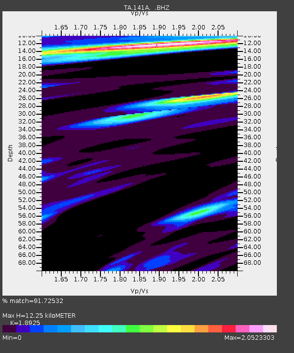
| Estimated Moho Depth: |
12.25 km |
| Estimated Crust Vp/Vs: |
1.89 |
| Assumed Crust Vp: |
6.245 km/s |
| Estimated Crust Vs: |
3.3 km/s |
| Estimated Crust Poisson's Ratio: |
0.31 |
|
| Radial Match: |
91.72532 % |
| Radial Bump: |
400 |
| Transverse Match: |
86.44494 % |
| Transverse Bump: |
400 |
| SOD ConfigId: |
446234 |
| Insert Time: |
2012-08-08 22:24:36.066 +0000 |
| GWidth: |
2.5 |
| Max Bumps: |
400 |
| Tol: |
0.001 |
|
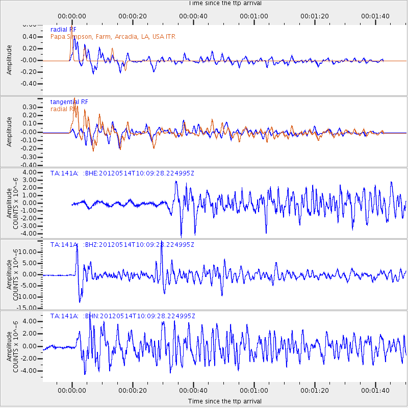
Signal To Noise
| Channel | StoN | STA | LTA |
| TA:141A: :BHZ:20120514T10:09:28.224995Z | 53.14121 | 6.0012317E-6 | 1.1292991E-7 |
| TA:141A: :BHN:20120514T10:09:28.224995Z | 8.785927 | 1.6877802E-6 | 1.9210043E-7 |
| TA:141A: :BHE:20120514T10:09:28.224995Z | 4.8581624 | 1.1524148E-6 | 2.3721208E-7 |
| Arrivals |
| Ps | 1.8 SECOND |
| PpPs | 5.4 SECOND |
| PsPs/PpSs | 7.3 SECOND |


