You are here: Home > Network List > G - GEOSCOPE Stations List
> Station NOUC Port Laguerre, New Caledonia > Earthquake Result Viewer
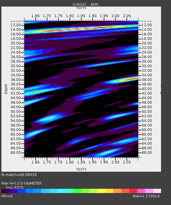
NOUC Port Laguerre, New Caledonia - Earthquake Result Viewer
| Earthquake location: |
E. Russia-N.E. China Border Reg. |
| Earthquake latitude/longitude: |
43.6/130.4 |
| Earthquake time(UTC): |
1999/04/08 (098) 13:10:34 GMT |
| Earthquake Depth: |
566 km |
| Earthquake Magnitude: |
6.4 MB, 7.1 MW, 7.1 MW |
| Earthquake Catalog/Contributor: |
WHDF/NEIC |
|
| Network: |
G GEOSCOPE |
| Station: |
NOUC Port Laguerre, New Caledonia |
| Lat/Lon: |
22.10 S/166.30 E |
| Elevation: |
112 m |
|
| Distance: |
73.2 deg |
| Az: |
145.345 deg |
| Baz: |
333.552 deg |
| Ray Param: |
0.05126584 |
| Estimated Moho Depth: |
13.5 km |
| Estimated Crust Vp/Vs: |
1.83 |
| Assumed Crust Vp: |
5.14 km/s |
| Estimated Crust Vs: |
2.813 km/s |
| Estimated Crust Poisson's Ratio: |
0.29 |
|
| Radial Match: |
88.59429 % |
| Radial Bump: |
400 |
| Transverse Match: |
85.92005 % |
| Transverse Bump: |
400 |
| SOD ConfigId: |
4480 |
| Insert Time: |
2010-02-26 23:35:20.403 +0000 |
| GWidth: |
2.5 |
| Max Bumps: |
400 |
| Tol: |
0.001 |
|

Signal To Noise
| Channel | StoN | STA | LTA |
| G:NOUC: :BHN:19990408T13:20:37.199019Z | 10.155509 | 1.08801605E-5 | 1.0713555E-6 |
| G:NOUC: :BHE:19990408T13:20:37.199019Z | 2.8996148 | 2.2452987E-6 | 7.743438E-7 |
| G:NOUC: :BHZ:19990408T13:20:37.199019Z | 3.9075274 | 2.4781293E-6 | 6.3419367E-7 |
| Arrivals |
| Ps | 2.2 SECOND |
| PpPs | 7.3 SECOND |
| PsPs/PpSs | 9.5 SECOND |


