You are here: Home > Network List > TA - USArray Transportable Network (new EarthScope stations) Stations List
> Station 243A Waterproof, LA, USA > Earthquake Result Viewer
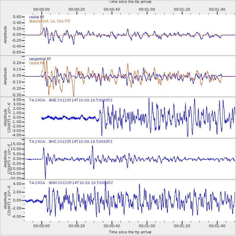
243A Waterproof, LA, USA - Earthquake Result Viewer
*The percent match for this event was below the threshold and hence no stack was calculated.
| Earthquake location: |
Peru-Bolivia Border Region |
| Earthquake latitude/longitude: |
-17.7/-69.6 |
| Earthquake time(UTC): |
2012/05/14 (135) 10:00:40 GMT |
| Earthquake Depth: |
106 km |
| Earthquake Magnitude: |
6.4 MB, 6.2 MW, 6.2 MW |
| Earthquake Catalog/Contributor: |
WHDF/NEIC |
|
| Network: |
TA USArray Transportable Network (new EarthScope stations) |
| Station: |
243A Waterproof, LA, USA |
| Lat/Lon: |
31.88 N/91.48 W |
| Elevation: |
2.0 m |
|
| Distance: |
53.6 deg |
| Az: |
336.779 deg |
| Baz: |
153.778 deg |
| Ray Param: |
$rayparam |
*The percent match for this event was below the threshold and hence was not used in the summary stack. |
|
| Radial Match: |
87.4299 % |
| Radial Bump: |
400 |
| Transverse Match: |
87.6729 % |
| Transverse Bump: |
400 |
| SOD ConfigId: |
446234 |
| Insert Time: |
2012-08-08 22:25:15.112 +0000 |
| GWidth: |
2.5 |
| Max Bumps: |
400 |
| Tol: |
0.001 |
|
Signal To Noise
| Channel | StoN | STA | LTA |
| TA:243A: :BHZ:20120514T10:09:19.599995Z | 50.95244 | 6.6304538E-6 | 1.3013026E-7 |
| TA:243A: :BHN:20120514T10:09:19.599995Z | 6.81401 | 1.4576813E-6 | 2.1392415E-7 |
| TA:243A: :BHE:20120514T10:09:19.599995Z | 5.5744433 | 1.1804E-6 | 2.1175207E-7 |
| Arrivals |
| Ps | |
| PpPs | |
| PsPs/PpSs | |


