You are here: Home > Network List > TA - USArray Transportable Network (new EarthScope stations) Stations List
> Station 242A Grayson, LA, USA > Earthquake Result Viewer
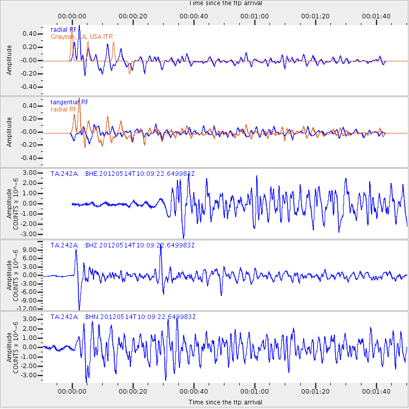
242A Grayson, LA, USA - Earthquake Result Viewer
*The percent match for this event was below the threshold and hence no stack was calculated.
| Earthquake location: |
Peru-Bolivia Border Region |
| Earthquake latitude/longitude: |
-17.7/-69.6 |
| Earthquake time(UTC): |
2012/05/14 (135) 10:00:40 GMT |
| Earthquake Depth: |
106 km |
| Earthquake Magnitude: |
6.4 MB, 6.2 MW, 6.2 MW |
| Earthquake Catalog/Contributor: |
WHDF/NEIC |
|
| Network: |
TA USArray Transportable Network (new EarthScope stations) |
| Station: |
242A Grayson, LA, USA |
| Lat/Lon: |
32.06 N/92.15 W |
| Elevation: |
57 m |
|
| Distance: |
54.0 deg |
| Az: |
336.248 deg |
| Baz: |
153.112 deg |
| Ray Param: |
$rayparam |
*The percent match for this event was below the threshold and hence was not used in the summary stack. |
|
| Radial Match: |
92.08479 % |
| Radial Bump: |
400 |
| Transverse Match: |
81.00475 % |
| Transverse Bump: |
400 |
| SOD ConfigId: |
446234 |
| Insert Time: |
2012-08-08 22:25:19.574 +0000 |
| GWidth: |
2.5 |
| Max Bumps: |
400 |
| Tol: |
0.001 |
|
Signal To Noise
| Channel | StoN | STA | LTA |
| TA:242A: :BHZ:20120514T10:09:22.649983Z | 44.778313 | 4.814812E-6 | 1.0752553E-7 |
| TA:242A: :BHN:20120514T10:09:22.649983Z | 11.650275 | 1.2869599E-6 | 1.1046606E-7 |
| TA:242A: :BHE:20120514T10:09:22.649983Z | 8.456457 | 9.803186E-7 | 1.1592546E-7 |
| Arrivals |
| Ps | |
| PpPs | |
| PsPs/PpSs | |


