You are here: Home > Network List > G - GEOSCOPE Stations List
> Station NOUC Port Laguerre, New Caledonia > Earthquake Result Viewer
NOUC Port Laguerre, New Caledonia - Earthquake Result Viewer

| Earthquake location: |
Taiwan Region |
| Earthquake latitude/longitude: |
24.0/122.7 |
| Earthquake time(UTC): |
2001/12/18 (352) 04:02:58 GMT |
| Earthquake Depth: |
14 km |
| Earthquake Magnitude: |
6.3 MB, 7.3 MS, 6.9 MW, 6.8 MW |
| Earthquake Catalog/Contributor: |
WHDF/NEIC |
|
| Network: |
G GEOSCOPE |
| Station: |
NOUC Port Laguerre, New Caledonia |
| Lat/Lon: |
22.10 S/166.30 E |
| Elevation: |
112 m |
|
| Distance: |
62.4 deg |
| Az: |
133.826 deg |
| Baz: |
314.626 deg |
| Ray Param: |
0.060260583 |
| Estimated Moho Depth: |
63.75 km |
| Estimated Crust Vp/Vs: |
2.07 |
| Assumed Crust Vp: |
5.14 km/s |
| Estimated Crust Vs: |
2.483 km/s |
| Estimated Crust Poisson's Ratio: |
0.35 |
|
| Radial Match: |
93.8479 % |
| Radial Bump: |
338 |
| Transverse Match: |
92.28364 % |
| Transverse Bump: |
400 |
| SOD ConfigId: |
20082 |
| Insert Time: |
2010-02-26 23:35:22.349 +0000 |
| GWidth: |
2.5 |
| Max Bumps: |
400 |
| Tol: |
0.001 |
|
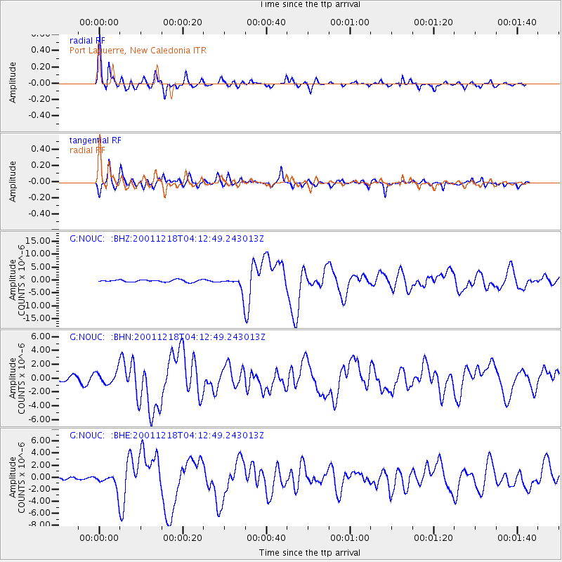
Signal To Noise
| Channel | StoN | STA | LTA |
| G:NOUC: :BHN:20011218T04:12:49.243013Z | 3.3467555 | 9.717536E-7 | 2.9035692E-7 |
| G:NOUC: :BHE:20011218T04:12:49.243013Z | 4.285665 | 1.4155626E-6 | 3.3030173E-7 |
| G:NOUC: :BHZ:20011218T04:12:49.243013Z | 7.7351704 | 3.2753285E-6 | 4.2343328E-7 |
| Arrivals |
| Ps | 14 SECOND |
| PpPs | 37 SECOND |
| PsPs/PpSs | 51 SECOND |


